Highlights:
- Weekly precipitation was minimal while evapotranspiration increased significantly due to warmer temperatures and windy conditions
- Soil moisture remains around normal for this time of year
- Stream conditions are below the median for this time of year for many streamflow gauges, while groundwater conditions are mixed, with some wells improving and others declining
- The seasonal outlook for May-July looks to be warm and wet for the Mid-Atlantic region
Statewide Drought Discussion
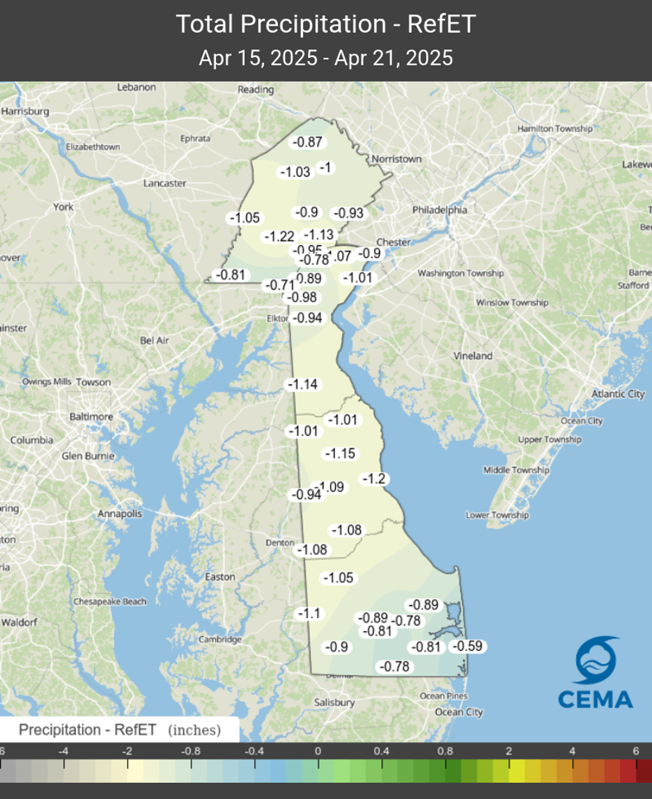
Drought conditions remained stable this past week, even though there was very little precipitation. Most of the state saw less than a tenth of an inch of rainfall, while portions of Sussex County (south of Georgetown) received about a quarter inch of rainfall on average. With warming temperatures, persistent windy conditions over much of last week, and the growing season in full swing, demand for water from the natural environment has increased accordingly. While evapotranspiration represents the process of water being lost from the soil and vegetation to the atmosphere, reference evapotranspiration can be used as a measure of evapotranspiration referenced to a specific land surface (i.e., grass). Data from the DEOS Network shows an average of 0.96 inches of water “lost” from the land surface to the atmosphere statewide in the last week. Since precipitation was less than the amount of water lost in the form of evapotranspiration last week, the State actually ran a small deficit in the surface water balance, which is equal to the amount of water received from precipitation minus the amount of water lost through evapotranspiration (P – ET). Figure 1 shows last week’s P-ET map from the DEOS network.
With the surface water balance deficit, soil moisture decreased slightly since last week. However, the upper 1 meter of soil is still within the normal range for this time of year, with the only exception being portions of southern New Castle County, where soil moisture conditions are slightly below normal (around the 20th to 25th percentile).
Stream conditions in New Castle County remained stable this past week on all three streams monitored for this report (White Clay Creek at Newark, White Clay Creek/Red Clay Creek combined, and the Brandywine Creek at Wilmington). The flows haven’t been at these levels since September 2024. Although the flows continue to move further from drought watch, they are still below their respective median flows for this time of year. Streamflows in Kent and Sussex Counties are also below their respective median flows. Continued precipitation will definitely help flows as we head into the spring season.
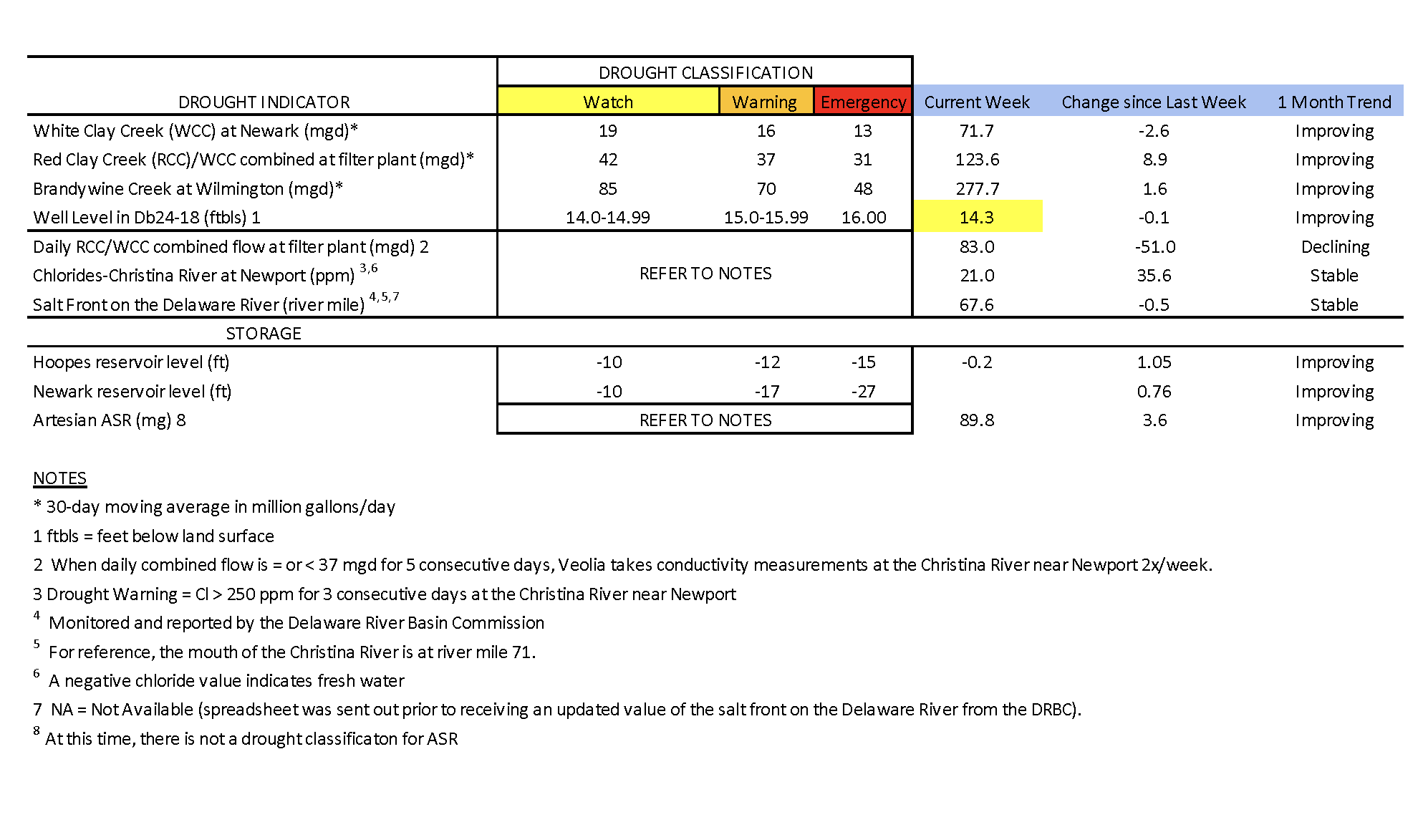
Chloride concentrations in the Christina River near Newport remain well below the first threshold of concern (250 ppm) at 21 ppm. Very fresh water is flowing down the Christina, pushing back any chlorides that may be present. The last time the chloride concentration was above 250 ppm was about six weeks ago during the first week of March (263.2 ppm). In general, chloride conditions have continued to be low throughout the first weeks of April as precipitation conditions have improved.
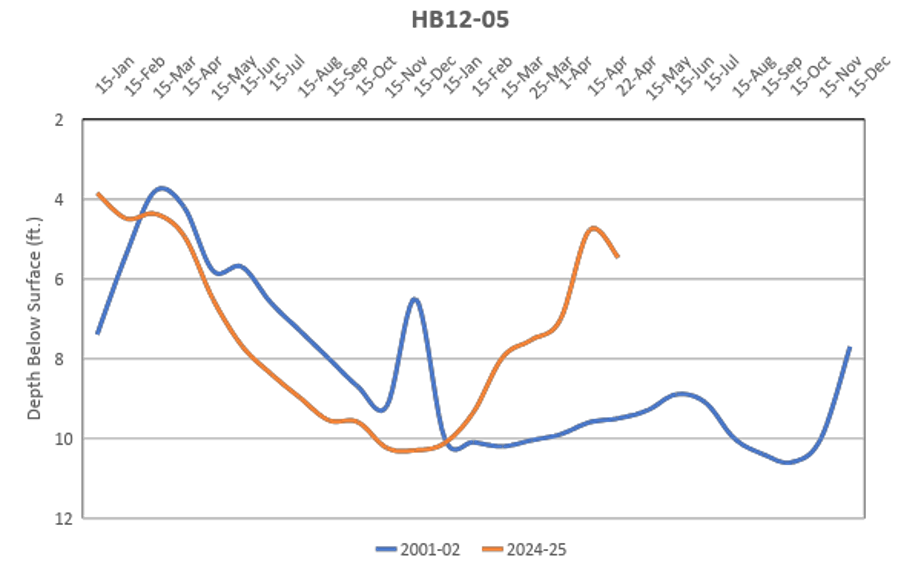
Groundwater conditions statewide are getting much closer to being normal for this time of year. The water level in well Db24-18 (located just south of Newark) has increased to 14.3 ft below land surface (Table 1). It is slowly starting to recharge, and is almost out of drought watch (14.0 to 14.99 ft below land surface). The water level in this well typically ranges between 9.7 and 13.3 feet below land surface during April. Meanwhile, USGS groundwater well Hb12-05 showed a notable decline in groundwater level (Figure 2). This well is located in the only part of the state with below normal soil moisture conditions, and groundwater demand is picking up with the growing season in full swing.
Groundwater conditions in Kent and Sussex Counties were mixed as well, with some monitoring wells showing signs of improvement, while others saw small declines.
Weather and Climate Outlook:
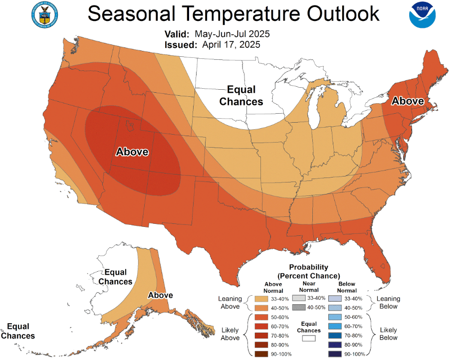
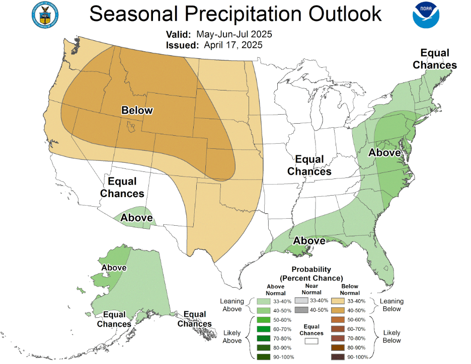
The NOAA Climate Prediction Center’s (CPC) outlook for the next couple of weeks is much above normal temperatures. This likely means temperatures in the 70’s and 80’s and higher evapotranspiration rates. We’ll need to see above average precipitation to continue seeing improvement in drought conditions statewide. While drought conditions in Sussex County and southern Kent County have largely dissipated, we are still abnormally dry or in a moderate drought elsewhere in Delaware according to the US Drought Monitor. New 3-month guidance available from the CPC shows the Mid-Atlantic region in warmer and wetter than normal conditions for the remainder of spring into early summer (Figures 3 and 4).