Highlights:
- Weekly precipitation was minimal throughout and exceeded precipitation in most parts of the state.
- No significant soil moisture concerns at this time, however, soil moisture conditions have continued to decline, while streams and surface aquifers have not rebounded since fall drought.
- Medium range forecasts show little precipitation with temperatures warmer than normal.
Statewide Drought Discussion
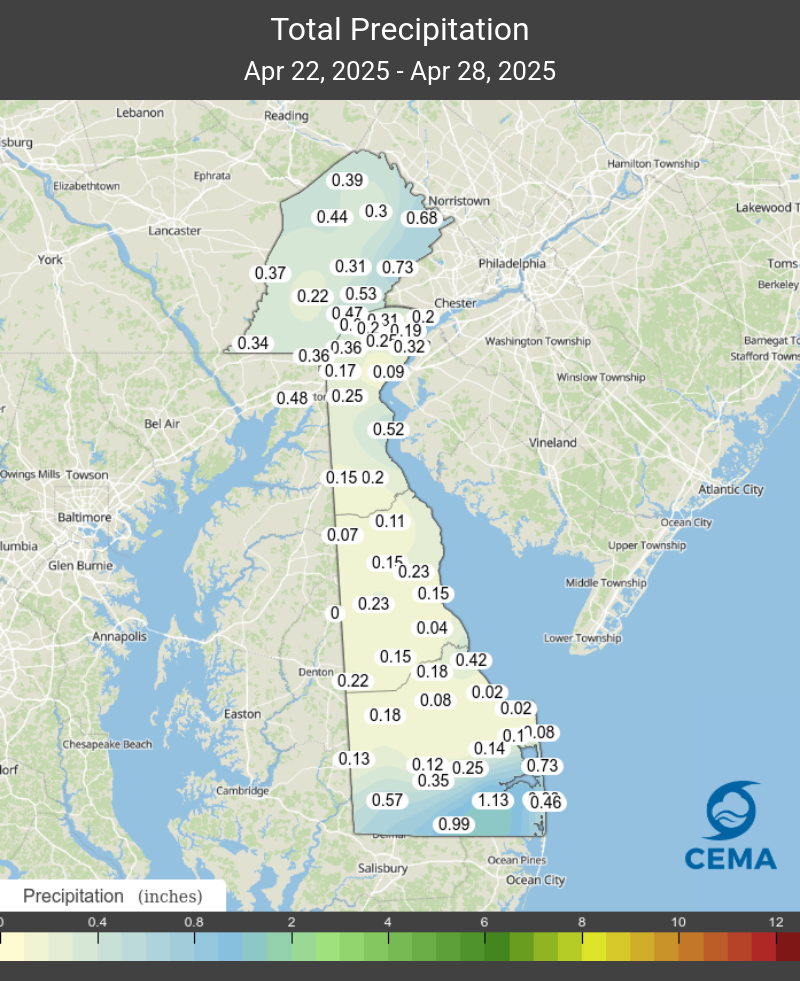
Very little precipitation fell across the state over the past week. The only exception was southern Sussex County, where locations such as Dagsboro, Gumboro, and Bethany Beach saw between 0.75 and 1.25 inches of rain from some storms that moved through on April 26th (Figure 1).
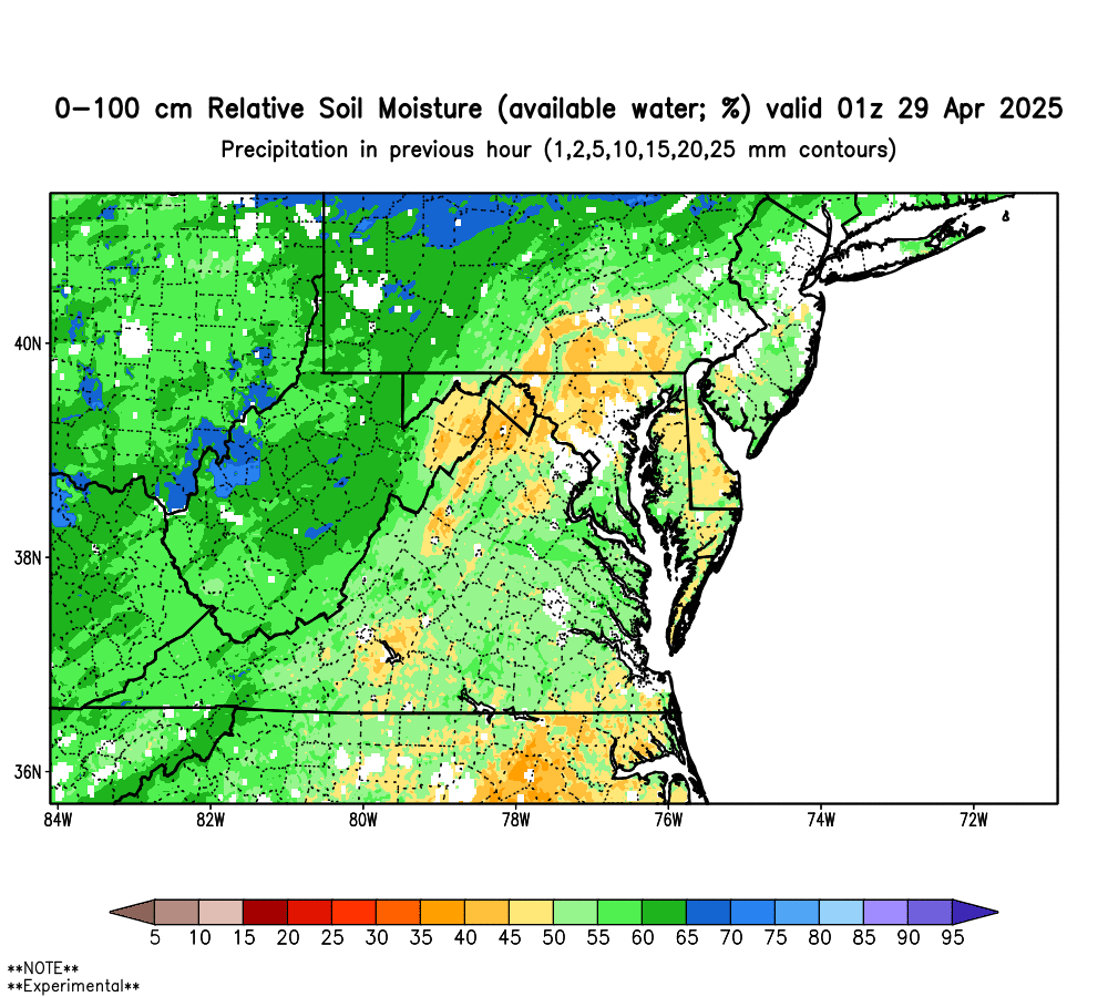
Likewise, every part of the state saw more water leave the environment through evapotranspiration than it gained through precipitation, with the exception of the aforementioned southern Sussex County. This meant that most of the state lost more water than it gained, which is normal most weeks during the growing season. However, given that our streams and surface aquifers haven’t fully recovered from the drought that set in last fall and lasted through the winter, it means that we are going to have difficulty bringing our groundwater levels up unless we get significant rain again soon. This also means soil moisture conditions continued to decrease, with most of Delaware now below 50% of field capacity (Figure 2). For now though, there is adequate soil moisture for most growing season needs, so there are no significant soil moisture concerns at this time.
Stream conditions in New Castle County slightly increased during the past week on all three streams monitored for this report (White Clay Creek at Newark, White Clay Creek/Red Clay Creek combined, and the Brandywine Creek at Wilmington). Although the flows continue to move further from drought watch, they are still below their respective median flows for this time of year. Since last October, the flows on all three streams have been similar to the flows during the late winter and early spring that led up to the drought of 2002. Streamflows in Kent and Sussex Counties are also below their respective median flows. Continued precipitation will be needed as we head into the mid- to late-spring season.
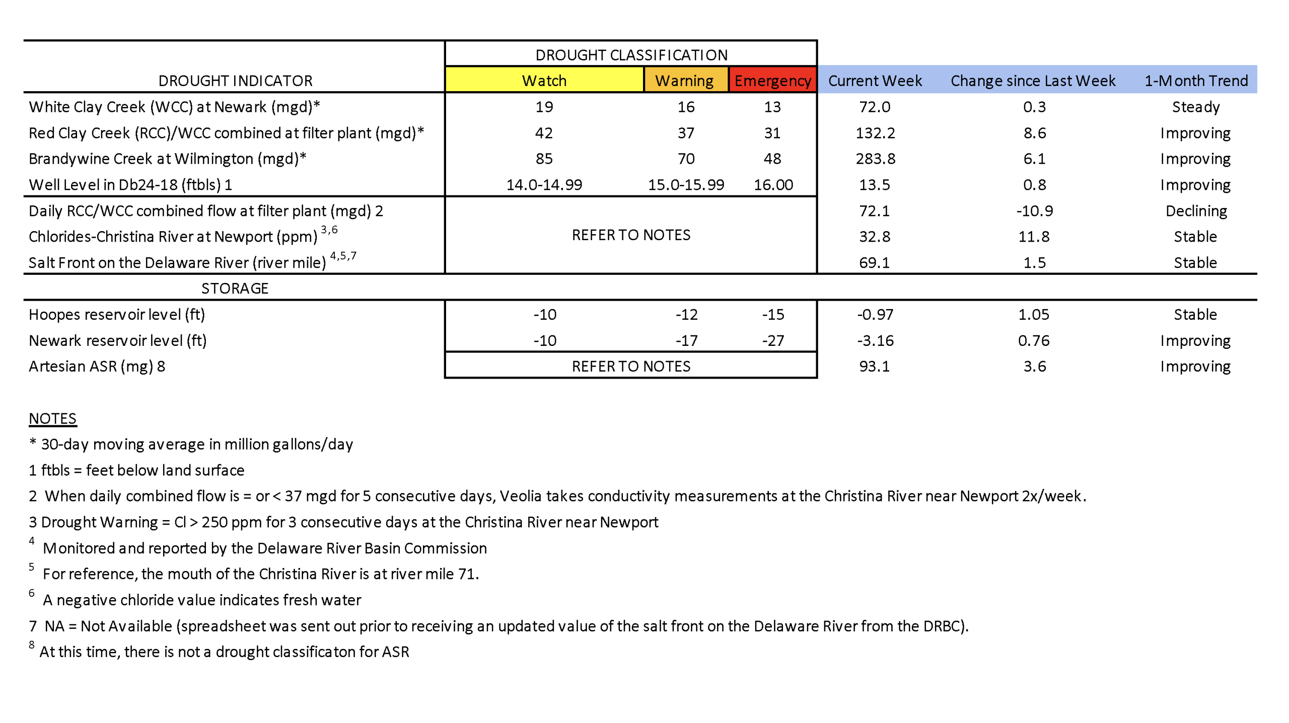
Chloride concentrations in the Christina River near Newport remain well below the first threshold of concern (250 ppm) at approximately 33 ppm. Very fresh water is flowing down the Christina, pushing back any chlorides that may be present. The last time the chloride concentration was above 250 ppm was about seven weeks ago during the first week of March (263.2 ppm). In general, chloride conditions have continued to be low throughout April as precipitation conditions have improved.
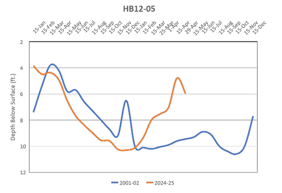
Groundwater conditions statewide are generally in good condition. However, many groundwater wells are below their median level for this time of year. The water level in well Db24-18 (located just south of Newark) increased to 13.5 ft below land surface (Table 1) and is finally out of drought watch but continues to remain slightly below normal. The water level in this well typically ranges between 9.7 and 13.3 feet below land surface during April. In central Sussex County, USGS groundwater well Pf24-02 showed a notable decline (~0.8 feet) in groundwater level over the last 2 weeks (Figure 3). Note that this same well saw a decline in its groundwater level in the spring of 2002, but the well level back then was over a foot lower than it is right now. Hopefully we can keep the generally wet pattern we’ve seen this spring going so as to not have a repeat of 2002.
Weather and Climate Outlook:
Medium range forecast models show a limited amount of precipitation over the next two weeks, with most of the state in the 1 to 1.5 inches range. Most of that forecast period takes place in May. Our statewide average precipitation for May for the 1991 to 2020 reference period is 3.58 inches. We’ll need a little more rain than what’s forecast for the next two weeks to stay on track for a normal rainfall month in May. The NOAA Climate Prediction Center is still expecting warmer than normal conditions for the first half of May, which means we should expect above normal evaporative demand conditions as well.