Note: The next drought report will be on August 6th, 2025.
Highlights:
- Delaware has received above-normal rainfall so far in July—averaging 5.2 inches statewide—due to intense thunderstorms and remnants of Tropical Cyclone Chantal.
- Soil moisture conditions are seasonable for this time of year.
- Streamflow and groundwater conditions are around the median (e.g., average) level for this time of year at most locations around the state.
- Warm and slightly wet conditions are expected throughout the remainder of July.
Statewide Drought Discussion
Drought conditions for the state have remained fairly stable over the last two weeks.
Precipitation
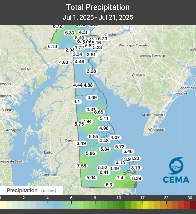
Although we have about a week left in July, most locations throughout Delaware are currently at or slightly above normal precipitation values. The statewide average precipitation so far for this month (Figure 1) is currently at 5.2 inches with a few locations in the state showing greater than 3.5 inches above the July normal of 4.4 inches. Since our last post on July 9th, the state, as a whole, has experienced numerous periods of intense rainfall from severe thunderstorms as well as the remnants of tropical cyclone Chantal. These storms brought high rainfall rates leading to some localized flooding. Overall, the state’s month-to-date rainfall is nearly 1 inch above the July monthly normal for precipitation.
Temperature/Evapotranspiration
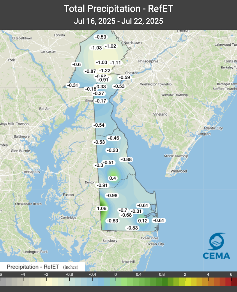
Month-to-date temperatures (July 1 – July 22) range slightly above normal throughout the state. Over the past two weeks, average statewide temperatures have risen slightly and this past week averaged 79 degrees, which is 1.6 degrees over the July normal. The relatively high humidity over the past few weeks (78% this week on average and 86% last week), has limited evapotranspiration to about 1.2 inches. Even though our month-to-date precipitation amounts are showing slightly above normal, last week’s rainfall was less than evapotranspiration demand and thus the state has an average deficit of -0.45 inches from July 16th to the 22nd (Figure 2).
Only a few locations in Delaware (located in southern Kent County as well as in Sussex County) are showing positive P-ET values with Seaford most noticeably standing out with 1.06 inches.
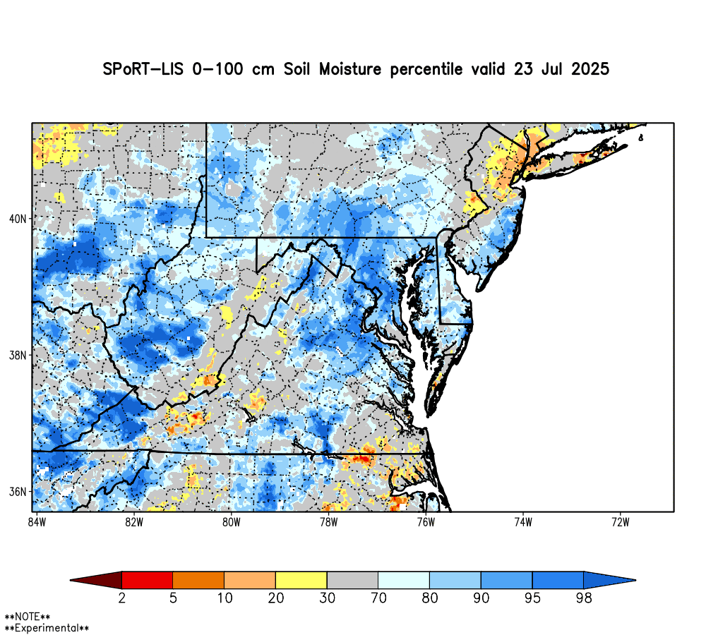
Soil Moisture
With the month-to-date precipitation slightly above normal, soil moisture conditions in the upper meter of soil is at or slightly above normal range throughout the state for this time of year (Figure 3). This generally means that the soil moisture conditions are seasonable for this time of year, which is important for drought considerations.
Streamflow
The daily average flows for all of the major streams in northern New Castle County have been hovering at or just above their respective medians for the past several weeks. It’s been since September 2024 since the 30-day average flows on both the White Clay Creek at Newark and on the White Clay Creek near Newark have been this high. In addition, it’s been since May 2024 since flows have been this high on the Brandywine. Summertime storms have helped maintain higher flows when they tend to decrease rapidly during days of high evapotranspiration. Thirty-day average flows on streams in Kent and Sussex Counties have also been hovering around their respective medians for the past couple of weeks.
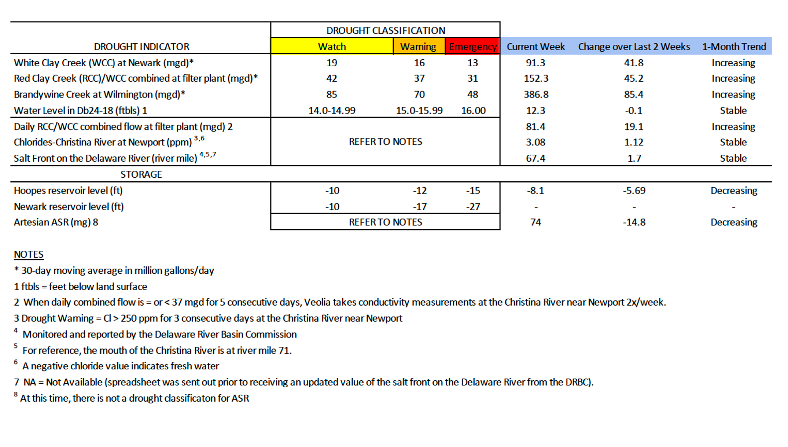
Chlorides
Chloride concentrations in the Christina River near Newport remain well below the first threshold of concern (250 ppm) at 3.08 ppm, and the salt front on the Delaware River has been below the 250 ppm threshold since at least mid-February.
Chloride concentrations have been very low since March 5th, when they reached 263.2 ppm.
Groundwater
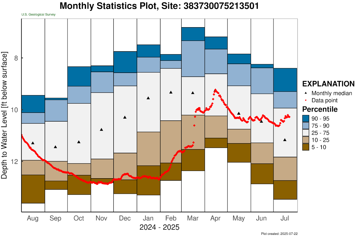
Groundwater conditions in the unconfined aquifer (i.e., surficial aquifer) in northern New Castle County remained steady over the past several weeks. DGS well Db24-18 (located just south of Newark) rose a bit to approximately 12.3 ft below land surface (Table 1), which is about 0.4 feet above the below normal level for this time of year. The water level in this well typically ranges between 10.1 and 12.7 feet below land surface during July. Elsewhere, groundwater levels around the state remain a mixed bag. Figure 3 shows the groundwater levels at USGS well Pf24-02, which is located in central Sussex County. Groundwater conditions there have started to rise as a result of the wet June and July experienced in that part of the state.
Weather and Climate Outlook
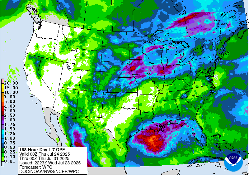
The precipitation outlook remains fairly dry over the next week with some severe thunderstorm activity forecasted for northern portions of Delaware in the next few days. As we close out the month’s precipitation totals next week, the amounts of precipitation from these storms are not anticipated to add greatly to the current totals (Figure 5). Temperatures are forecasted to be very hot and humid over the next few days, but this should subside by the weekend. Overall, conditions will likely bring little to no change in the current drought conditions.
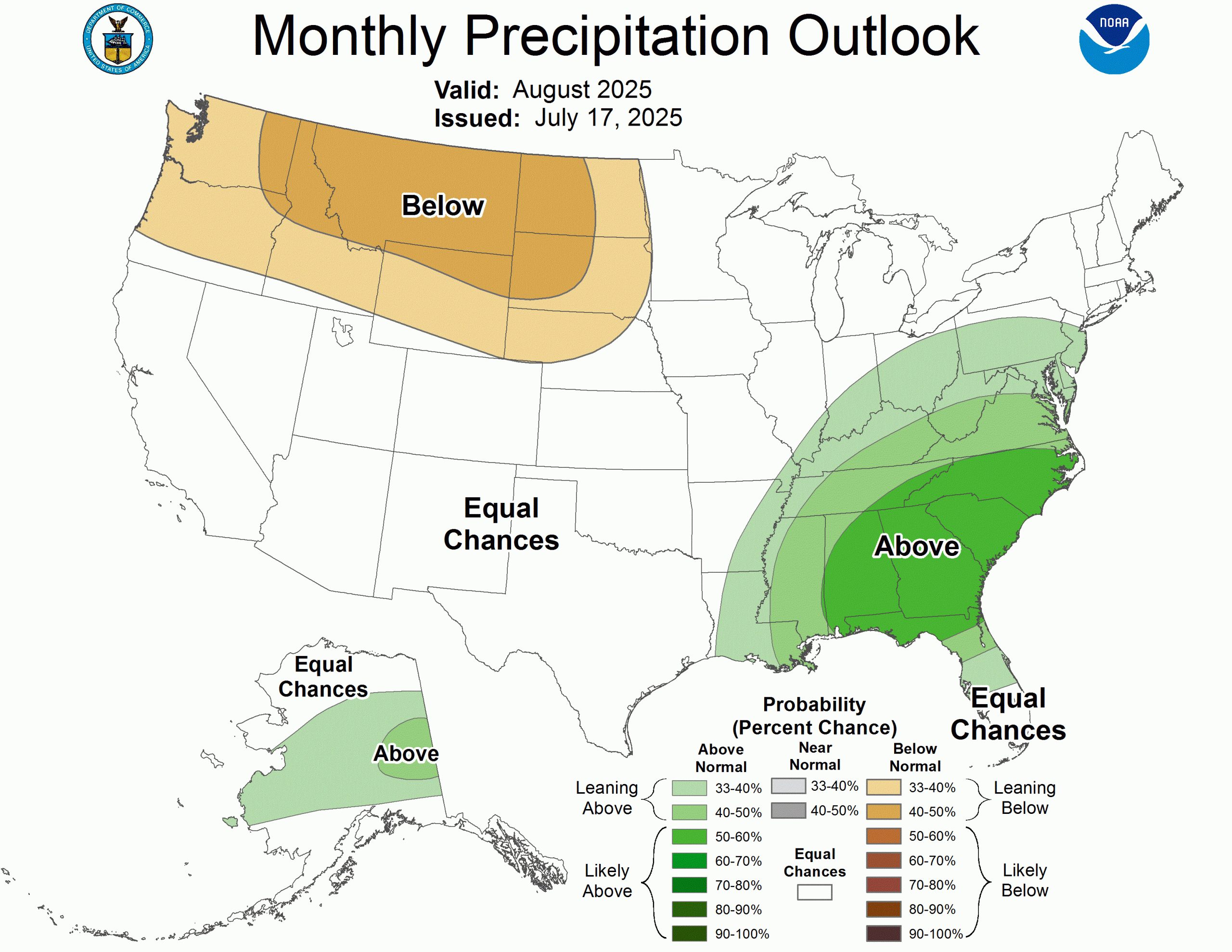
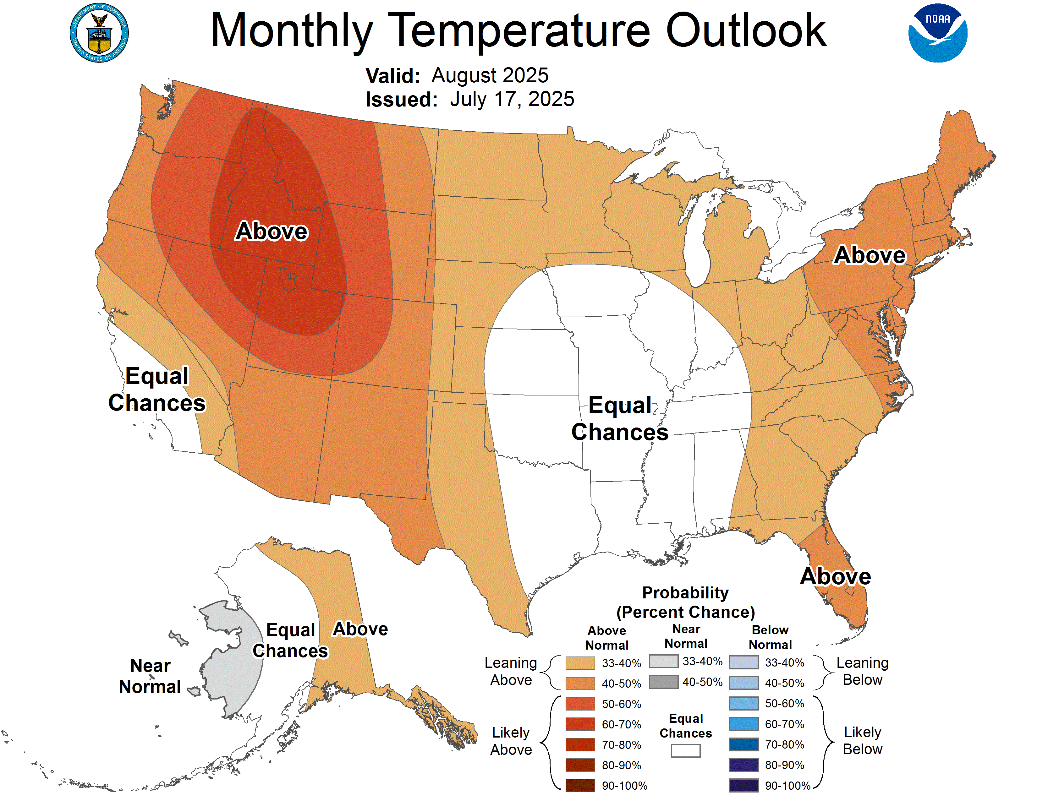
Looking ahead to the month of August, NOAA’s Climate Prediction Center is predicting slightly above normal chances of wet conditions (Figure 6) with above normal temperatures (Figure 7). With little to no current activity in the tropical outlooks, the precipitation needed will have to come from elsewhere (ie. fronts and convective rainfall).