Highlights:
- Rainfall totals were highly variable last week, but every location in Delaware saw at least some rain.
- Below normal temperatures kept evapotranspiration rates down statewide, however most locations still saw a small deficit (< 0.50 inches) in the water balance for the week.
- Streamflows and groundwater levels are, for the most part, holding steady
- Temperatures for the remainder of June will likely be well above normal, leading to higher evapotranspiration rates. Rainfall over this timeframe does not look substantial, so continued water balance deficits are likely.
Statewide Drought Discussion
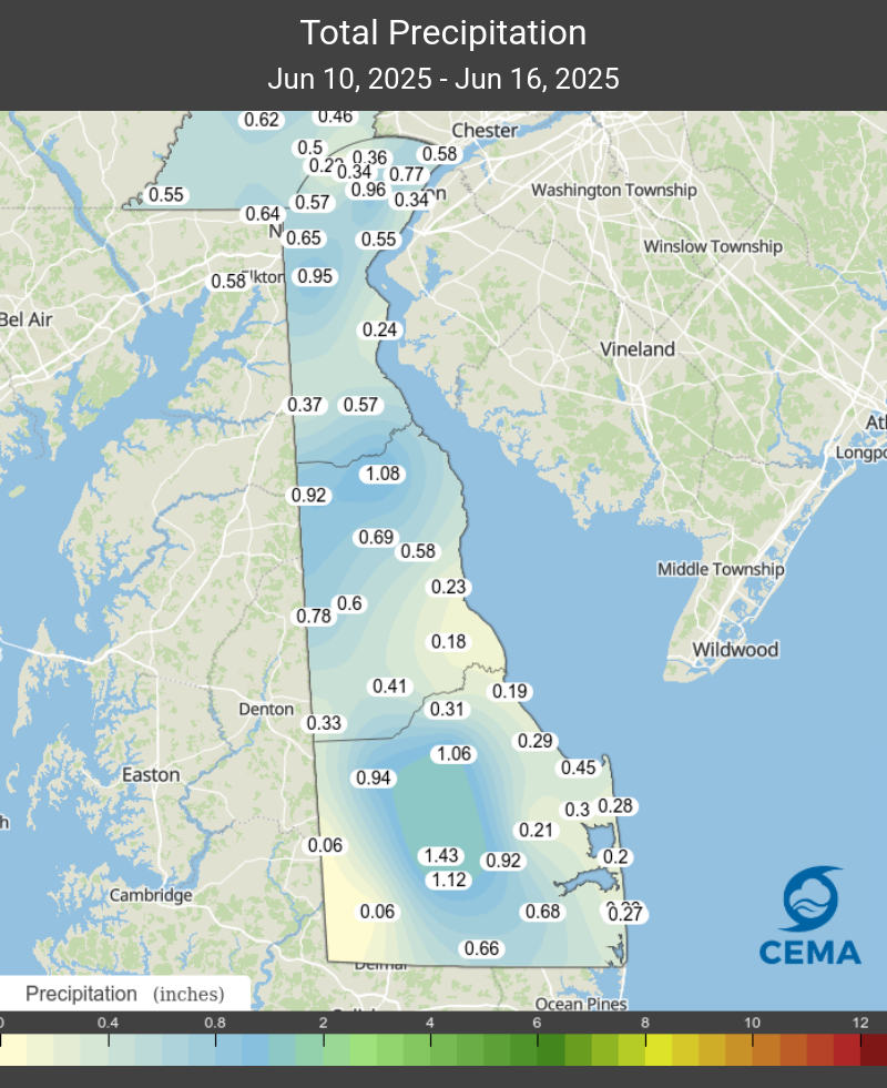
All of Delaware saw at least some rain last week. However, the amount varied quite a bit from location to location (see Figure 1). The Georgetown area saw the most rain, yet, in typical summertime fashion, nearby Laurel and Seaford received less than tenth of an inch of rain. Other areas that saw significant rainfall last week were northern Kent County and along the I-95 corridor in New Castle County.
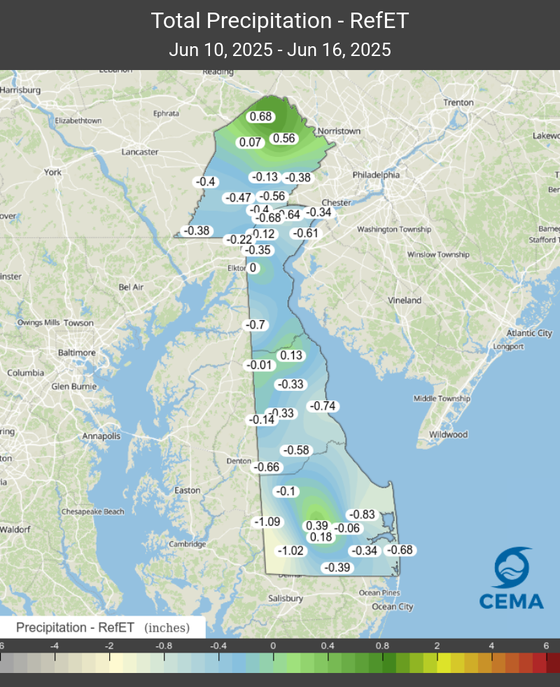
Temperatures were mostly below normal the last 7 days, particularly between the 14th and 17th. This was mainly due to a stalled out frontal boundary that kept our weather unsettled. With lots of clouds and cooler than normal temperatures, reference evapotranspiration (RefET) rates were much lower than usual for most of last week. These conditions resulted in small water balance deficits for most locations in Delaware (Figure 2). Usually at this time of year, Delaware sees large (> -1.00 inch) Precipitation-RefET deficits unless significant rainfall occurs.
For the past week, the streamflows in the northern part of the state are very close to their respective medians for this time of year. With lower evapotranspiration rates last week, streamflows held steady throughout the state. Significant precipitation will be needed to keep flows at this level as temperatures begin to rise next week, and evapotranspiration kicks into high gear. Flows on streams in Kent and Sussex Counties vary quite a bit, as some streamflows are at their respective medians, while other streamflows are much below their median value.
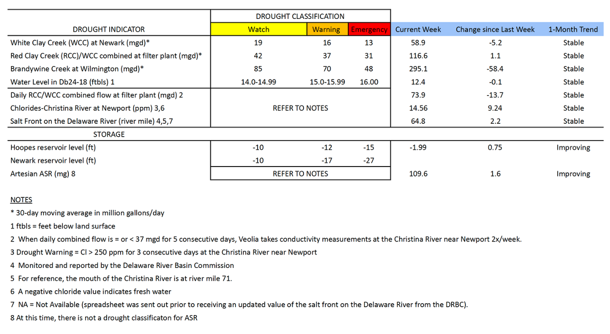
Chloride concentrations in the Christina River near Newport remain well below the first threshold of concern (250 ppm) at 14.56 ppm. The last time the chloride concentration was above 250 ppm was during the first week of March (263.2 ppm). In general, chloride conditions have been very low thus far in June. Chlorides on the Delaware River have been well below the 250 ppm threshold since at least mid-February. The low concentrations on the Delaware River are also influencing the low chloride concentrations on the Christina River.
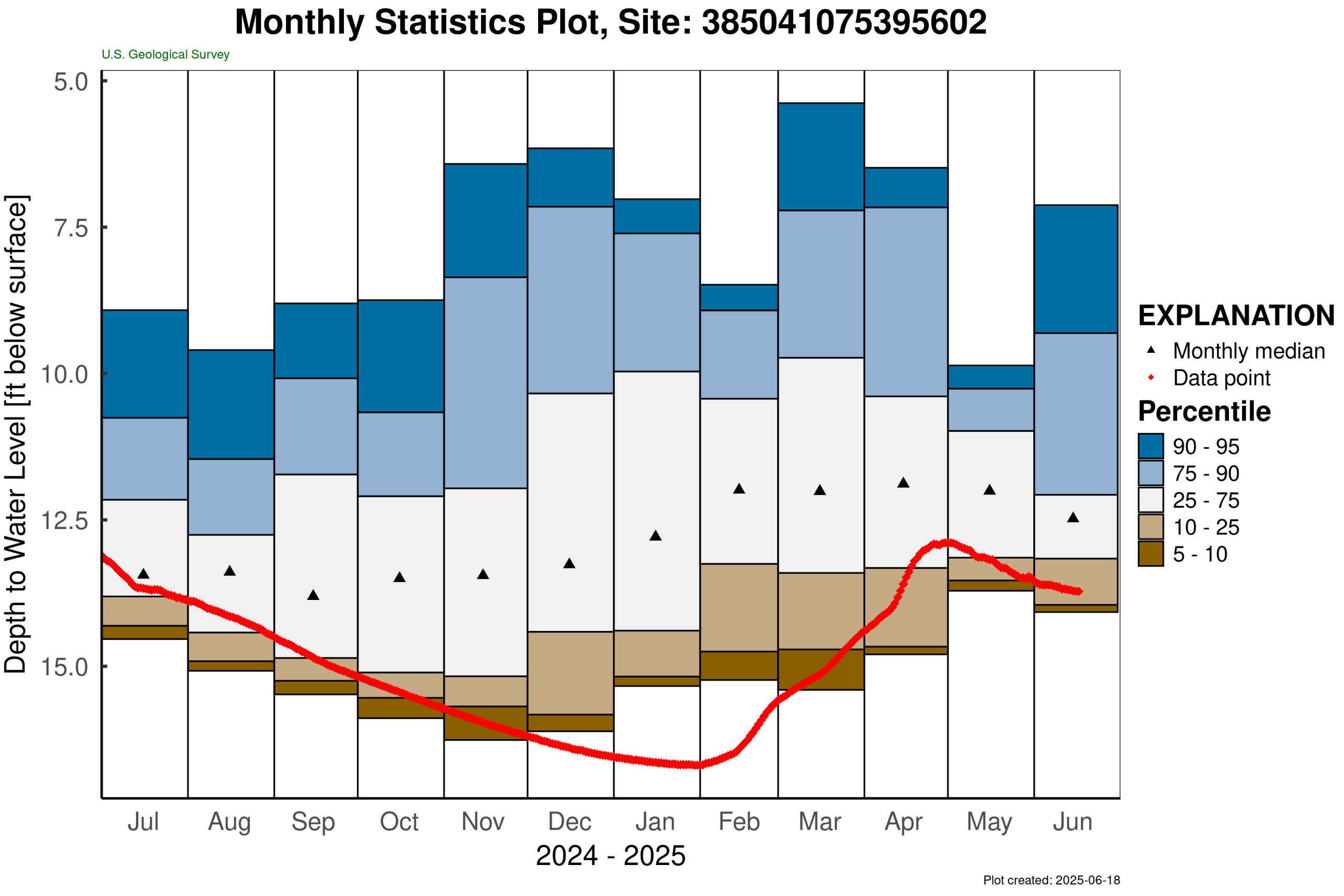
Groundwater conditions in the unconfined aquifer (i.e., surficial aquifer) in northern New Castle County continued to recharge slightly over the past week. DGS well Db24-18 (located just south of Newark) continued its slow recovery from the drought earlier this year. The groundwater level in this well is at 12.4 ft below land surface (Table 1), which is about 0.5 feet above the below normal level for this time of year. The water level in this well typically ranges between 9.4 and 12.9 feet below land surface during June. About the only long-term monitoring well in Delaware with below normal (i.e., below the 25th percentile) levels right now is USGS well Mc51-01a, located in southern Kent County. This well is currently between the 10th and 25th percentile, but its rate of decline has slowed from a few weeks ago, likely as a result of significant rainfall that area has seen over the last 30 days (Figure 3).
Weather and Climate Outlook:
Much warmer temperatures are expected over the next week, which will mean much higher reference evapotranspiration rates throughout Delaware. Rainfall over that same timeframe is not expected to be substantial, so a water balance (i.e., Precipitation-RefET) deficit is likely next week. Once again, warmer than normal temperatures are expected throughout most of the summer, so this may only be the tip of the iceberg. Looking at the 8-14 day guidance from NOAA’s Climate Prediction Center (CPC), much above normal temperatures expected for the Mid-Atlantic region through the end of the month.