Highlights:
- Delaware saw substantial rainfall last week, with many places receiving at least 2-3 inches of rain.
- May 2025 will likely be one of the ten wettest Mays in Delaware’s 130 year observation record
- Excellent soil moisture conditions are currently in place in Delaware for this time of year
- Stream conditions are holding steady, while groundwater conditions continue to show signs of improvement
- More seasonable weather conditions are expected over the next couple of weeks as we see a more typical summer weather pattern develop across the Mid-Atlantic region
Statewide Drought Discussion
Last week was one the wettest weeks Delaware has experienced in quite awhile. Wilmington New Castle County Airport received nearly 3 inches of rain (2.98” to be exact), which is the wettest 7-day period (May 25th – May 31st) that the official National Weather Service monitoring station has seen since August 12th, 2024, which was just before the 2024-2025 Drought began. Figure 1 shows that the Wilmington-New Castle area wasn’t even the area of the state that saw the greatest rainfall totals over the past week.
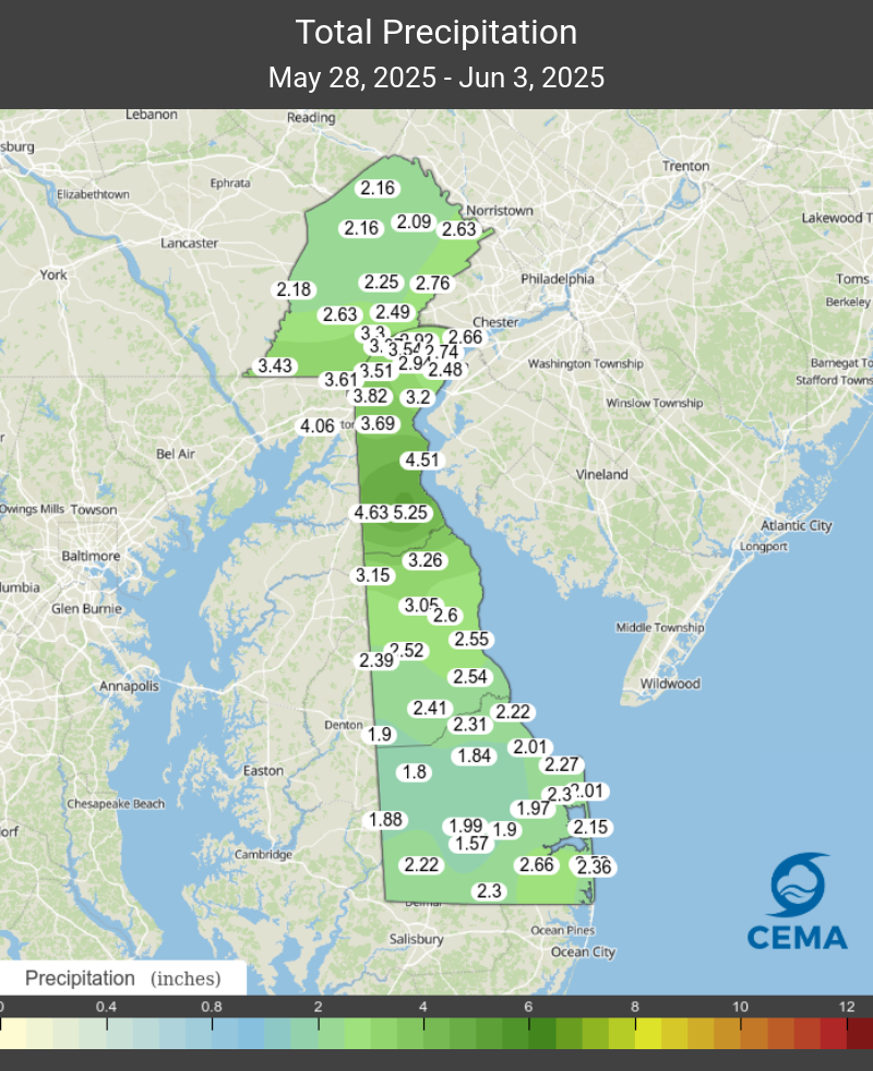
Southern New Castle County was the high spot statewide, with Blackbird exceeding 5 inches of rainfall! Elsewhere, 2-3 inches of rain was common, with slightly higher rainfall totals throughout New Castle County and slightly lower amounts in western and central Sussex County. Official monthly statistics for Delaware won’t be available until next week from NOAA’s National Centers for Environmental Information (NCEI), but the Delaware Climate Office’s preliminary analysis indicates May 2025’s statewide precipitation will be about 3 inches above normal. That would make last month a potential Top 5 all-time May in the state’s 130+ year observation record.
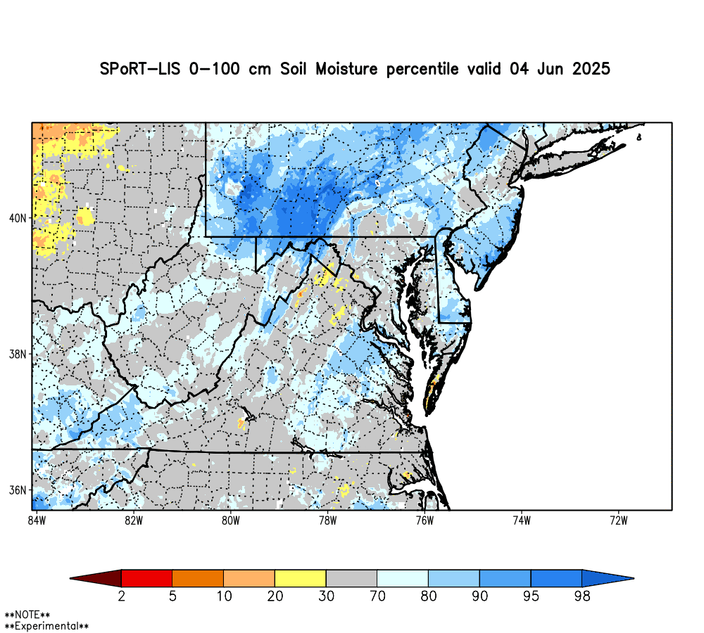
As you might expect, a wet week has translated into excellent soil moisture conditions across Delaware. While a few areas are a little on the soggy side, most locations are sitting in a good place with relative soil moisture values around 55-60% relative soil moisture in the top meter of soil. Figure 2 shows that pretty much all of Delaware is now in the 70th to 90th percentile for soil moisture this time of year. That’s a good place to be in when the growing season is in full swing.
Despite very wet conditions last week, streamflows remained relatively stable in New Castle County. Overall, water conditions remain in “catch up” mode across northern Delaware; however, the receding limb of the hydrographs for streams in the northern part of the state are actually very close to their respective medians for this time of year. Flows on most streams in Kent and Sussex Counties, however, continue flowing below their respective means.
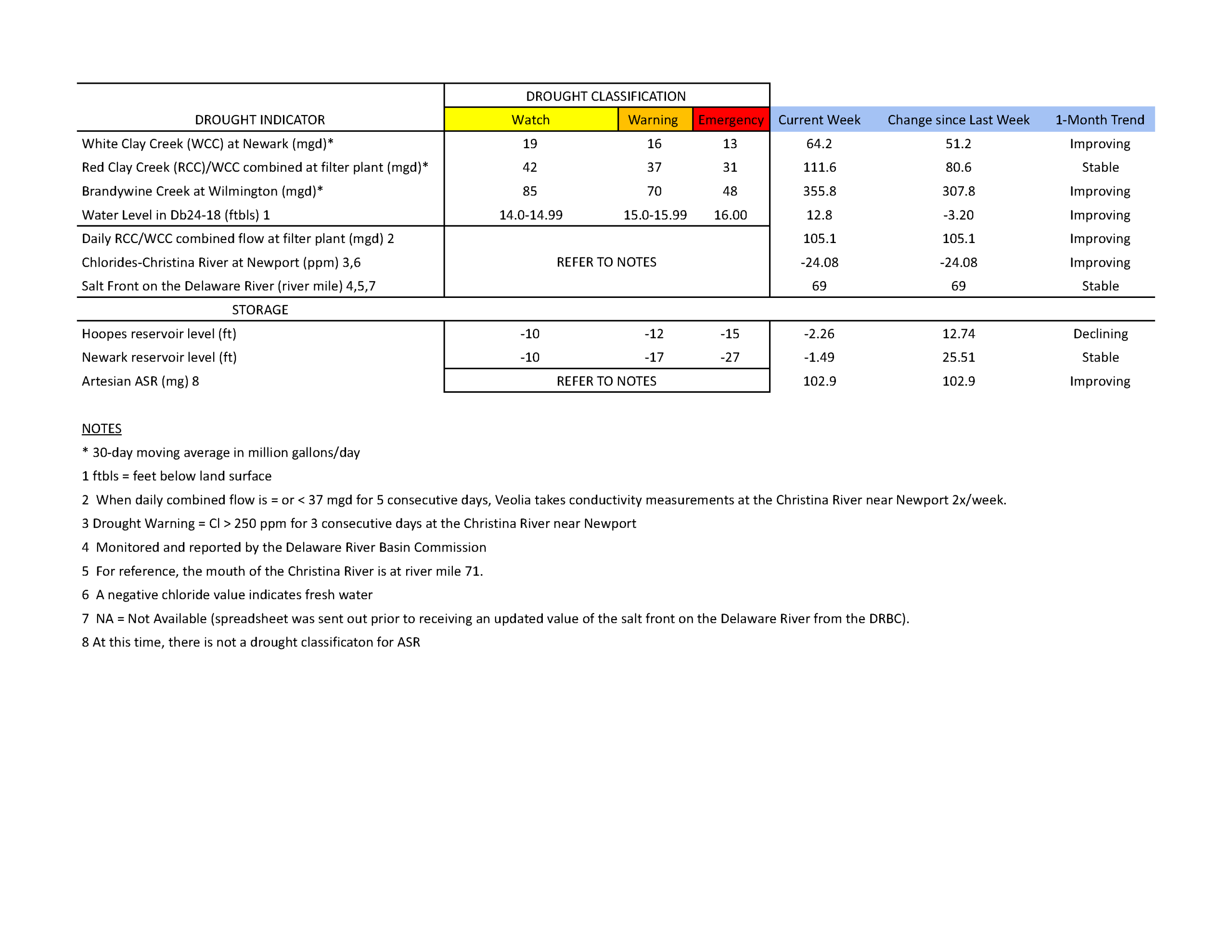
Chloride concentrations in the Christina River near Newport remain well below the first threshold of concern (250 ppm) at approximately -24.08 ppm (the negative number indicates very fresh water coming down the stream). The last time the chloride concentration was above 250 ppm was about nine weeks ago during the first week of March (263.2 ppm). In general, chloride conditions continued to remain low throughout May and remain low during the first few days of June. Chlorides on the Delaware River have been well below the 250 ppm threshold since at least mid-February, which helps contribute to the low chloride concentrations on the Christina River.
Groundwater conditions in the unconfined aquifer (i.e., surficial aquifer) continued to recharge slightly over the past week. One long-term monitoring well that continues its slow recovery is DGS well Db24-18 (located just south of Newark). The groundwater level in this well was at 12.8 ft below land surface last week (Table 1), which is about 0.1 feet above the below normal level for this time of year. The water level in this well typically ranges between 9.4 and 12.9 feet below land surface during June. Because this well is used to monitor drought conditions in northern Delaware, the rise in water level, although at the very low end of normal, is no longer in Drought Watch status. One well that has responded very quickly to the recent rainfall is USGS well Hb12-05. As Figure 3 shows, groundwater levels for this location in southern New Castle County are above the 90th percentile for June.
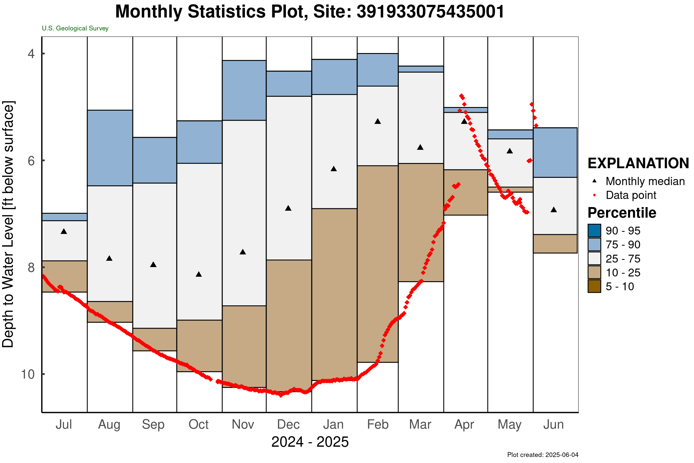
While this location also tends to see quick declines in well level, this improvement in groundwater conditions is very promising and is consistent with the area that saw the greatest rainfall in Delaware during the past week.
Weather and Climate Outlook:
Medium range forecast models suggest that Delaware should remain generally on the wet side over the next 7 to 10 days. Beyond that, things don’t look too wet or too dry. Overall, this suggests a more typical weather pattern for June, which tends to be one of our wetter months annually. As we head into more summer season weather patterns, we’ll likely see greater spatial variability in our rainfall patterns. This is due to convective thunderstorms becoming a more prominent factor in our rainfall patterns during the summer months. That said, NOAA’s Climate Prediction Center is still expecting Delaware to see above normal precipitation this summer. Hopefully that will be enough to keep us from dropping back into drought later this summer.