Highlights:
- Precipitation departures over the last 30 days are 1 to 3 inches below normal, with Kent County seeing the greatest departures
- Soil moisture conditions declined further last week, with some portions of the state seeing 4 to 8% declines in relative soil moisture in the upper layer of soil
- Groundwater levels have dropped off considerably at most monitoring wells over the last few weeks due to high levels of evapotranspiration combined with limited rainfall
- There is some potential relief over the next couple of weeks, as conditions are expected to be cooler and wetter than normal
Statewide Drought Discussion
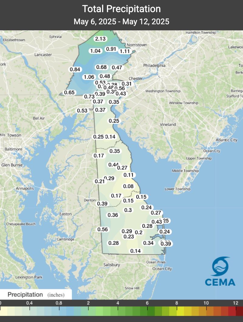
Precipitation continued to be scarce over the last week. Delaware really missed out on most of the rain that fell in our region late last week, with most of the state seeing less than a half an inch of precipitation (Figure 1).
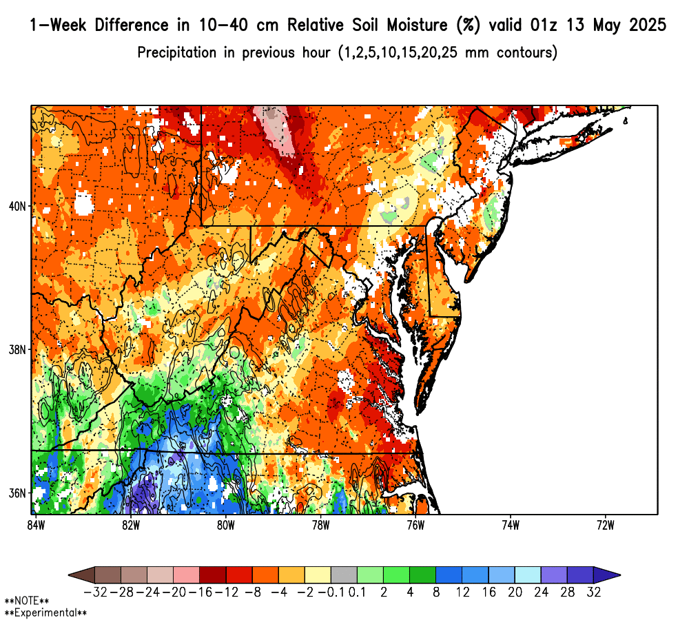
The lack of precipitation resulted in another week where evapotranspiration exceeded precipitation by 0.62 inches on average for the DEOS Network. Another deficit in our weekly water balance caused soil moisture levels to drop as well. Figure 2 shows a 4 to 8 percent decrease in relative soil moisture over the last seven days. Soil moisture conditions in portions of Delaware where the soils have a sandier texture (i.e., western Sussex and Kent Counties) are drying out pretty rapidly with the higher than normal evapotranspiration rates and limited precipitation. Conditions are not too bad yet, but if we continue to see weekly water balance deficits, soil moisture conditions could deteriorate to levels that would affect early growing season crops.
With minimal precipitation received last week, streamflows in New Castle County decreased slightly on all three streams monitored for water supply conditions in northern New Castle County (White Clay Creek at Newark, White Clay Creek/Red Clay Creek combined, and the Brandywine Creek at Wilmington). Streamflows remain below their respective median values for this time of year. Since last October, the flows on all three New Castle County streams have been similar to flows during the late winter and early spring leading up to the drought of 2002. Streamflows in Kent and Sussex Counties continue to be below their respective median flows overall, and well below their median flows for this time of year. One example is the USGS stream gauge on the Nanticoke River in Bridgeville, DE, where streamflow is currently at the 7th percentile for May 13th.
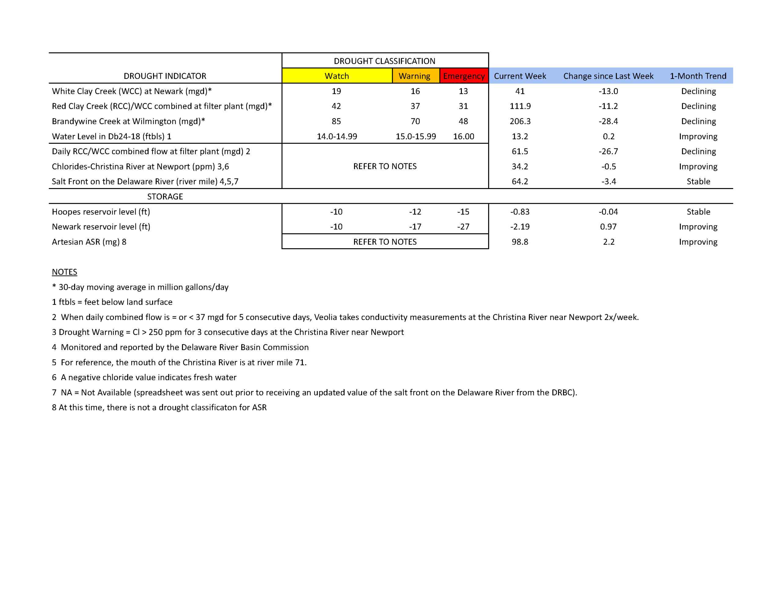
Chloride concentrations in the Christina River near Newport remain well below the first threshold of concern (250 ppm) at approximately 34.2 ppm. Sufficient fresh water is flowing down the Christina, pushing back any chlorides that may be present. The last time the chloride concentration was above 250 ppm was about eight weeks ago during the first week of March (263.2 ppm). In general, chloride conditions continued to remain low throughout the first half of May.
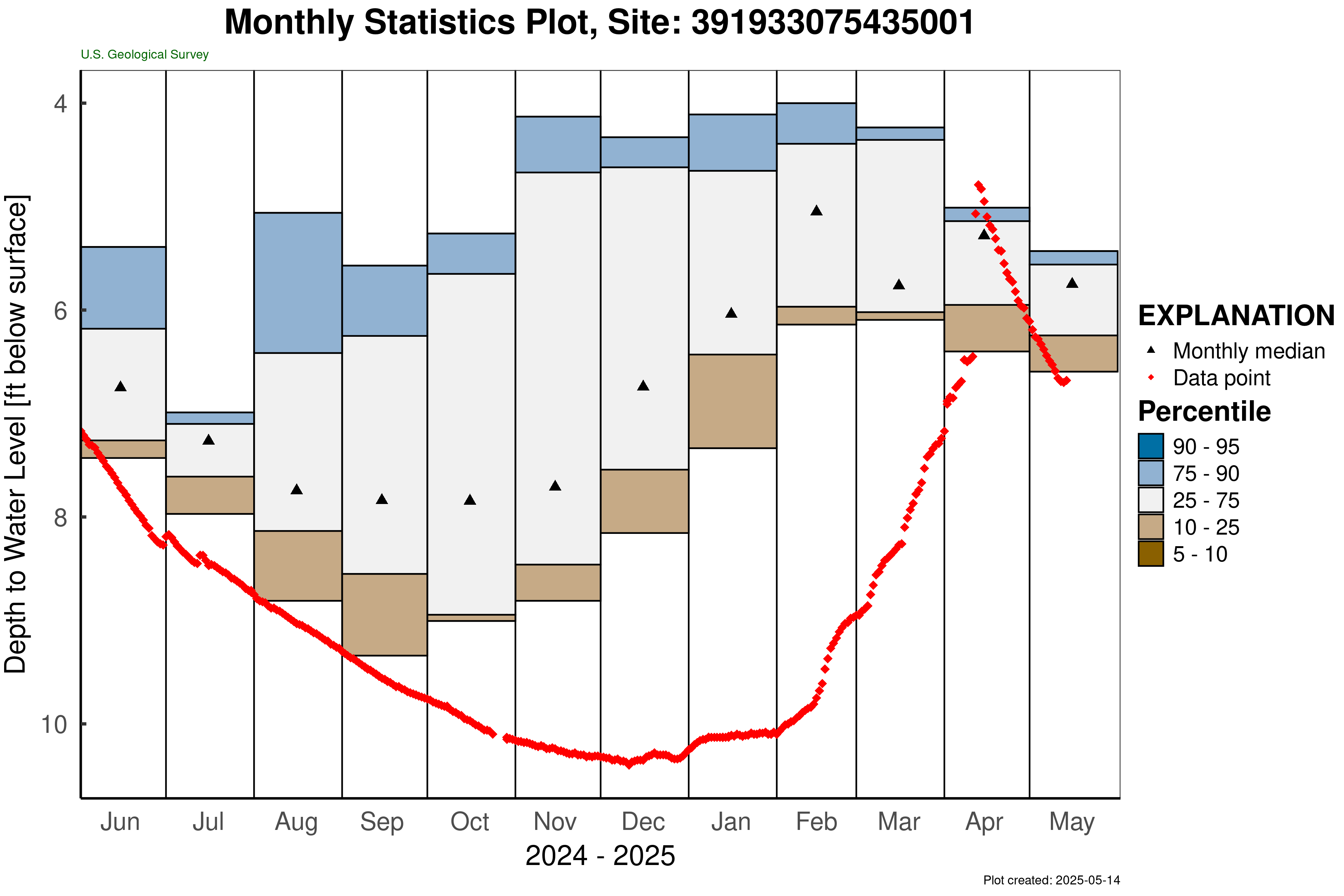
Nearly every long-term groundwater monitoring well in the unconfined aquifer (i.e., surficial aquifer) has started to show declining groundwater levels. The exception is DGS well Db24-18 (located just south of Newark), which increased to 13.2 ft below land surface (Table 1). This well is above its drought watch threshold, but continues to remain approximately one foot below normal for this time of year. The water level in this well typically ranges between 8.0 and 12.6 feet below land surface during May. Meanwhile, USGS well Hb12-05 (located in SW New Castle County) has shown a rapid decline in well level over the last few weeks, dropping over a foot in that timeframe (Figure 3).
Overall, groundwater levels are still adequate, but a significant rain event (e.g., 1-2 inches) will be necessary to slow the recent declines we have seen in groundwater levels.
Weather and Climate Outlook:
An atmospheric river event is likely to affect the Mid-Atlantic region over the next few days. Forecast rain totals from the National Weather Service’s Weather Prediction Center show the potential for over 2 inches of rain in portions of Delaware. While atmospheric rivers can bring very intense rainfall for one area, they also can have sharp drop offs (i.e., gradients) such that locations not far away can see considerably less rainfall. If we miss out on this rainfall event, we could be in store for another week with a water balance deficit, or at the very least, a week with minimal recovery from the recent dry conditions.
Looking at the next couple of weeks, NOAA’s Climate Prediction Center has the northeastern United States (including Delaware) with below normal temperatures and above normal precipitation. If this prediction comes to fruition, that could mean some improvement in our water conditions.