Highlights:
- Precipitation balanced out evapotranspiration this past week, keeping soil moisture levels stable.
- Stream conditions remain stable, but still below their median values for this time of year
- Groundwater levels in the unconfined aquifer are steadily declining across most of the state
- Ample rainfall is likely over the next week, which should keep soil moisture conditions in good shape across Delaware
Statewide Drought Discussion
Precipitation was sufficient enough last week to balance out the evaporative loss from the environment across most of Delaware. The exceptions were in southern New Castle County around Townsend and SW Kent County around Harrington, where slightly less precipitation fell (Figure 1).
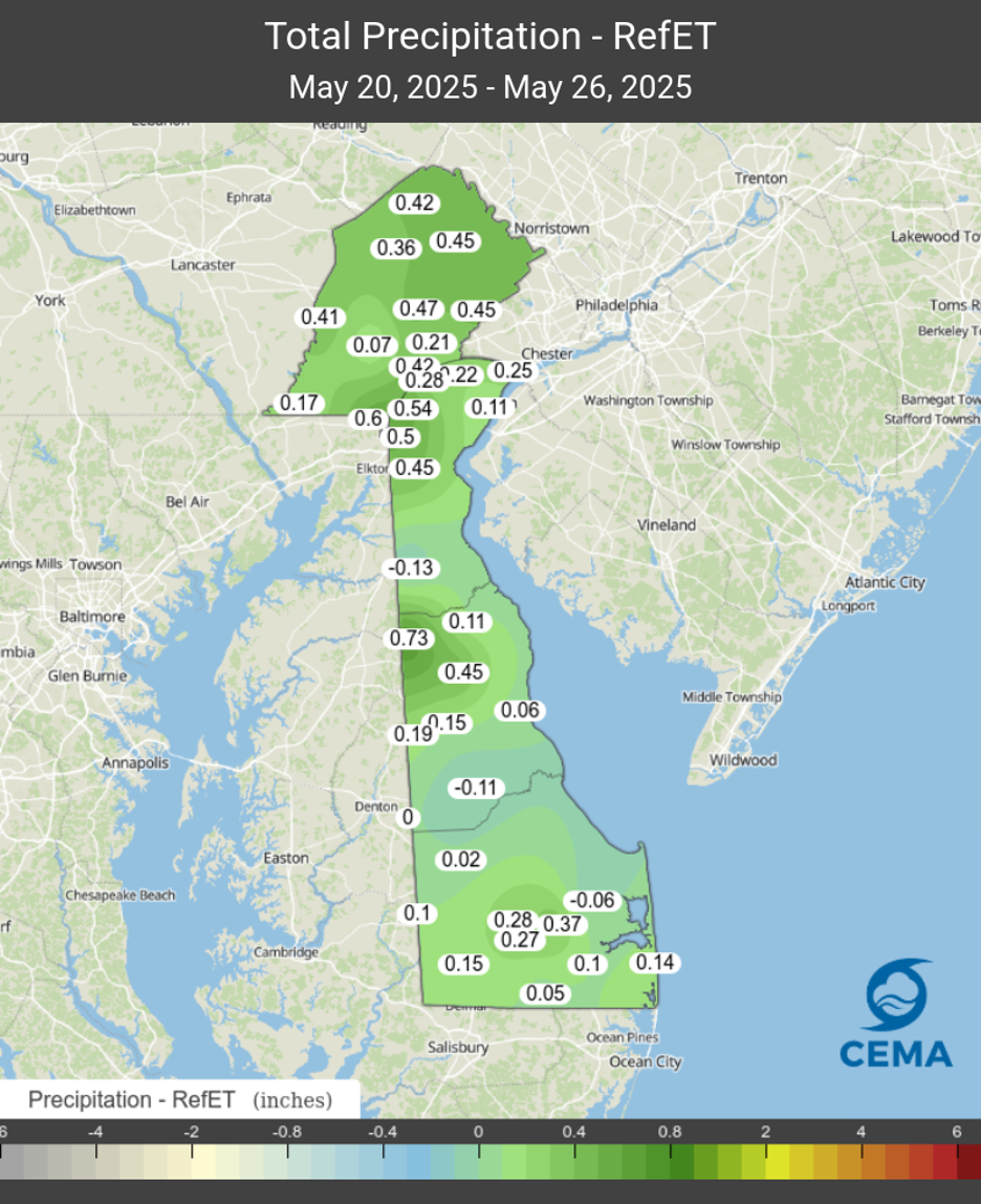
On average, stations across the DEOS Network came out about 0.25 inches “ahead” for the week, meaning they received more precipitation than they lost through evapotranspiration. In spite of this slight surplus in the water balance, soil moisture conditions changed very little last week across Delaware. However, most locations in Delaware still have sufficient soil moisture for most agricultural and landscaping needs.
Despite generally wet conditions last week, streamflows remained relatively stable in New Castle County. With water conditions still in “catch up” mode across northern Delaware and in the headwaters of the northern creeks, streamflows remain below their respective median values for this time of year. In fact, the USGS stream gage on Blackbird Creek at Blackbird is only 0.3 cfs above the lowest flow of record for this time of year, which was set in 1977. Streamflows for most stream gages in Kent and Sussex Counties also continue to be below their respective median flows for this time of year.
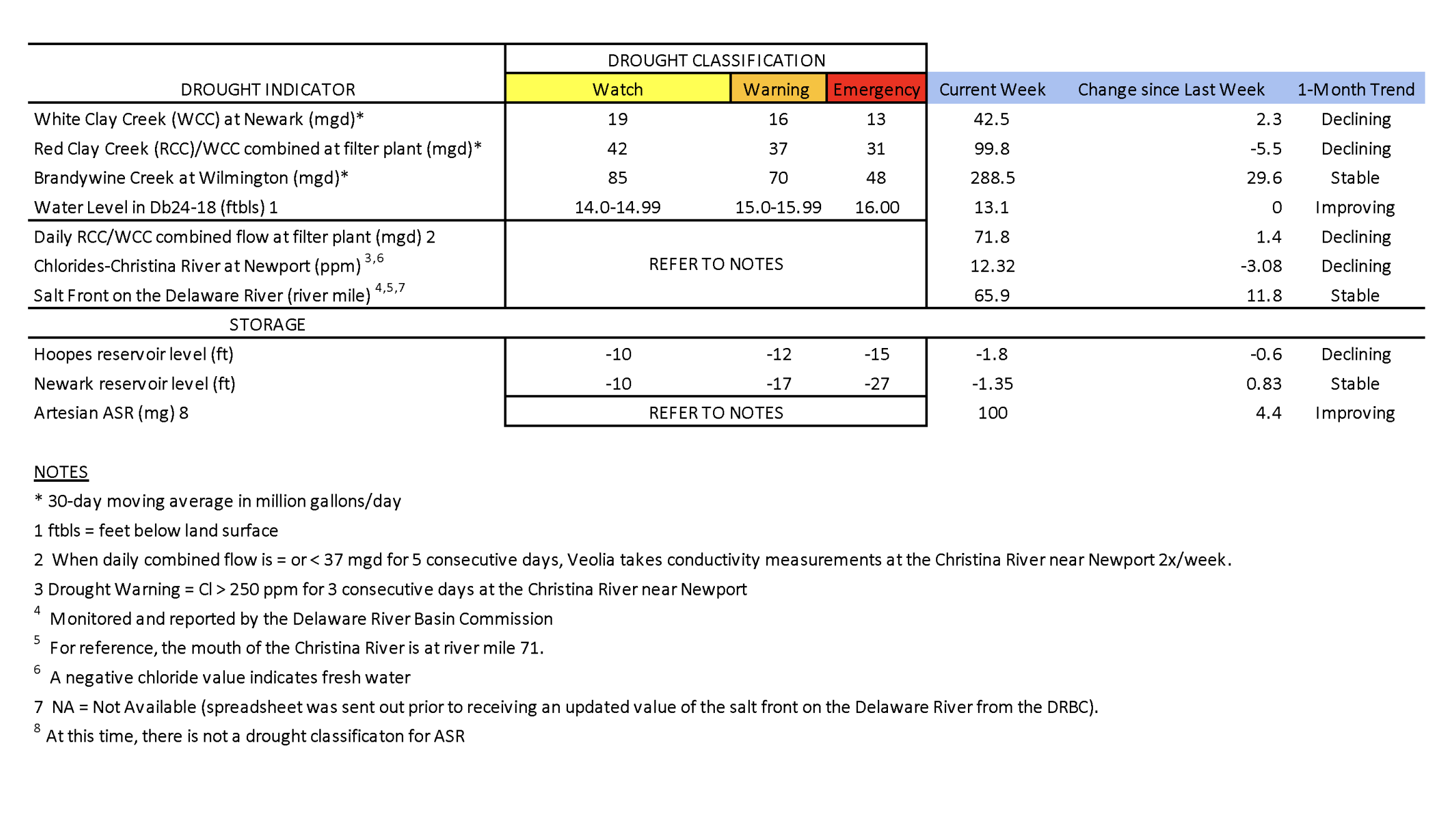
Chloride concentrations in the Christina River near Newport remain well below the first threshold of concern (250 ppm) at approximately 12 ppm. Sufficient fresh water is flowing down the Christina, pushing back any chlorides that may be present. The last time the chloride concentration was above 250 ppm was about nine weeks ago during the first week of March (263.2 ppm). In general, chloride conditions continued to remain low throughout the first half of May. Chlorides on the Delaware River have been well below the 250 ppm threshold since at least mid-February, which helps contribute to the low chloride concentrations on the Christina River near Newport.
Groundwater conditions in the unconfined aquifer (i.e., surficial aquifer) continued to decline slightly over the past week. However, one long-term monitoring well that has seen little change is DGS well Db24-18 (located just south of Newark). This well remained at 13.1 ft below land surface last week (Table 1), which is about 0.5 feet below normal for this time of year. The water level in this well typically ranges between 8.0 and 12.6 feet below land surface during May. This level also keeps groundwater conditions in northern New Castle County out of Drought Watch.
One thing to remember as we head into the summer months, is that our long-term water conditions (> 6 months) are still not where we would like them to be. This is mainly because of the extended dry period from August of last year through February of this year. A good way to visualize this potential issue can be seen in Figure 2, which shows Georgetown’s cumulative precipitation for 2024-2025 compared to the same time period in 2001-2002.
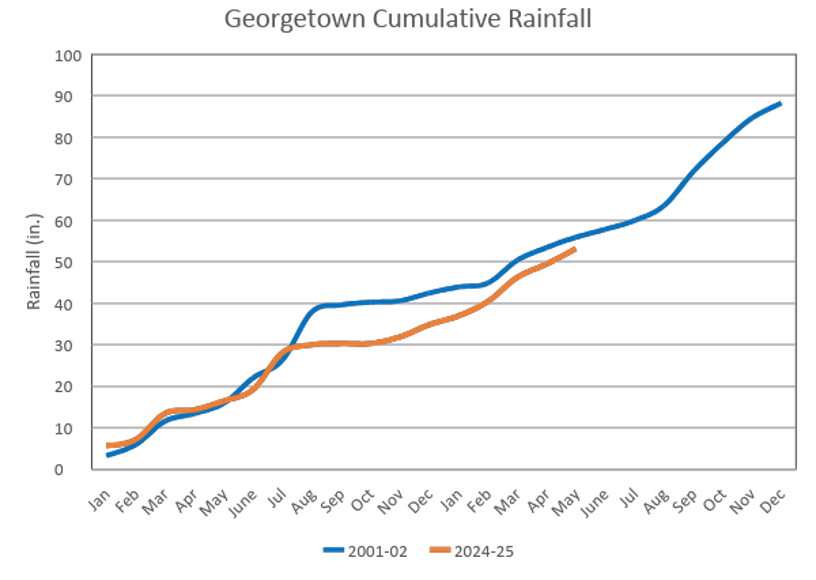
Note how cumulative precipitation since the beginning of 2024 is still below cumulative precipitation from January 2001 through May 2002. This is significant because 2002 was when the last major statewide drought occurred in Delaware. Just like this year, the spring of 2002 was also reasonably wet. However, when the rainfall slowed down later that summer, groundwater and stream conditions were still quite low, which allowed drought conditions to intensify rapidly and led to an exceptional (D4) drought for most of Delaware in August of 2002. In fact, August of 2002 is the only month when D4 has ever been depicted for Delaware in the 25 year history of the United States Drought Monitor. Hopefully nothing like that happens this year, but it’s certainly something that bears watching as the calendar crosses into June next week.
Weather and Climate Outlook:
As this discussion is being posted, it’s raining across the First State. The current weather system is expected to bring a decent amount of rain, with most places seeing 1.0 to 1.5 inches. A few locations may even see over 2 inches by the time this system moves out of here late Wednesday into Thursday. Another drenching storm system will move through over the weekend, bringing even more rain to Delaware. As long as this forecast verifies, this should mean that surface water conditions will remain stable (if not improve) again next week.
Another item to monitor as we head into the summer months is the upcoming hurricane season. NOAA’s National Hurricane Center recently came out with their 2025 forecast, and the expectation right now is for a slightly above normal season. Why does this matter for Delaware? Because historically, many of our summer/fall droughts have ended in the late summer/early fall as a result of rainfall from a tropical system. Hopefully we can avoid a direct hit from a tropical system, but sometimes the rain from one can be beneficial as long as it’s not too excessive, such as the remnants of Hurricane Ida in September of 2021.