Highlights:
- Very little precipitation over the last week besides a few locations in Delaware. However, wet conditions in March and April have kept 30, 60, and 90 day precipitation departures in the normal range for this time of year
- Stream conditions are low for this time of year, but still adequate for now.
- Groundwater levels declined due to elevated evapotranspiration rates and minimal precipitation over the last few weeks
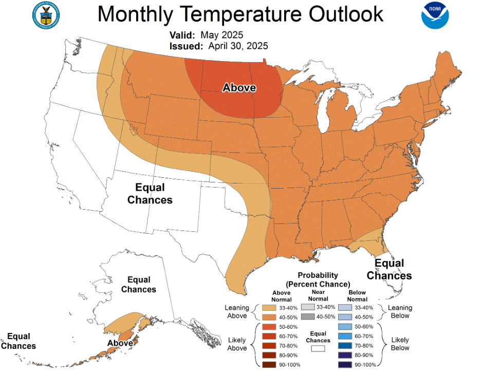
- Above normal temperatures will likely continue for the month of May
Statewide Drought Discussion
The recent trend of limited precipitation continued this past week. The DEOS Network’s average rainfall since 4/29 was only 0.55 inches, which is below normal for this time of year. Meanwhile, evapotranspiration rates have been increasing with warmer temperatures. Looking at the surface water balance, which can be described as the difference between precipitation and evapotranspiration, we’ve been running a pretty good deficit since mid-April (4/15). Figure 1 shows that nearly every location in Delaware has been in deficit since then.
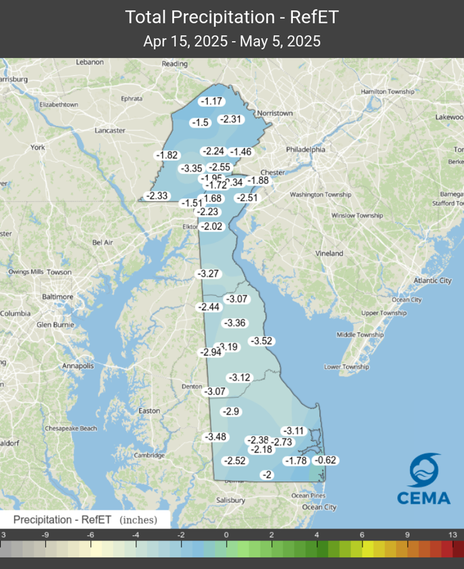
The network-wide average deficit was 2.39 inches over this period, meaning that we have significantly more water through evapotranspiration than we gained through precipitation.
Although we received some precipitation this past week, streamflows in New Castle County decreased slightly on all three streams monitored for this report (White Clay Creek at Newark, White Clay Creek/Red Clay Creek combined, and the Brandywine Creek at Wilmington). Streamflows remain below their respective median values for this time of year. Since last October, the flows on all three New Castle County streams have been similar to flows during the late winter and early spring leading up to the drought of 2002. Streamflows in Kent and Sussex Counties are also below their respective median flows.
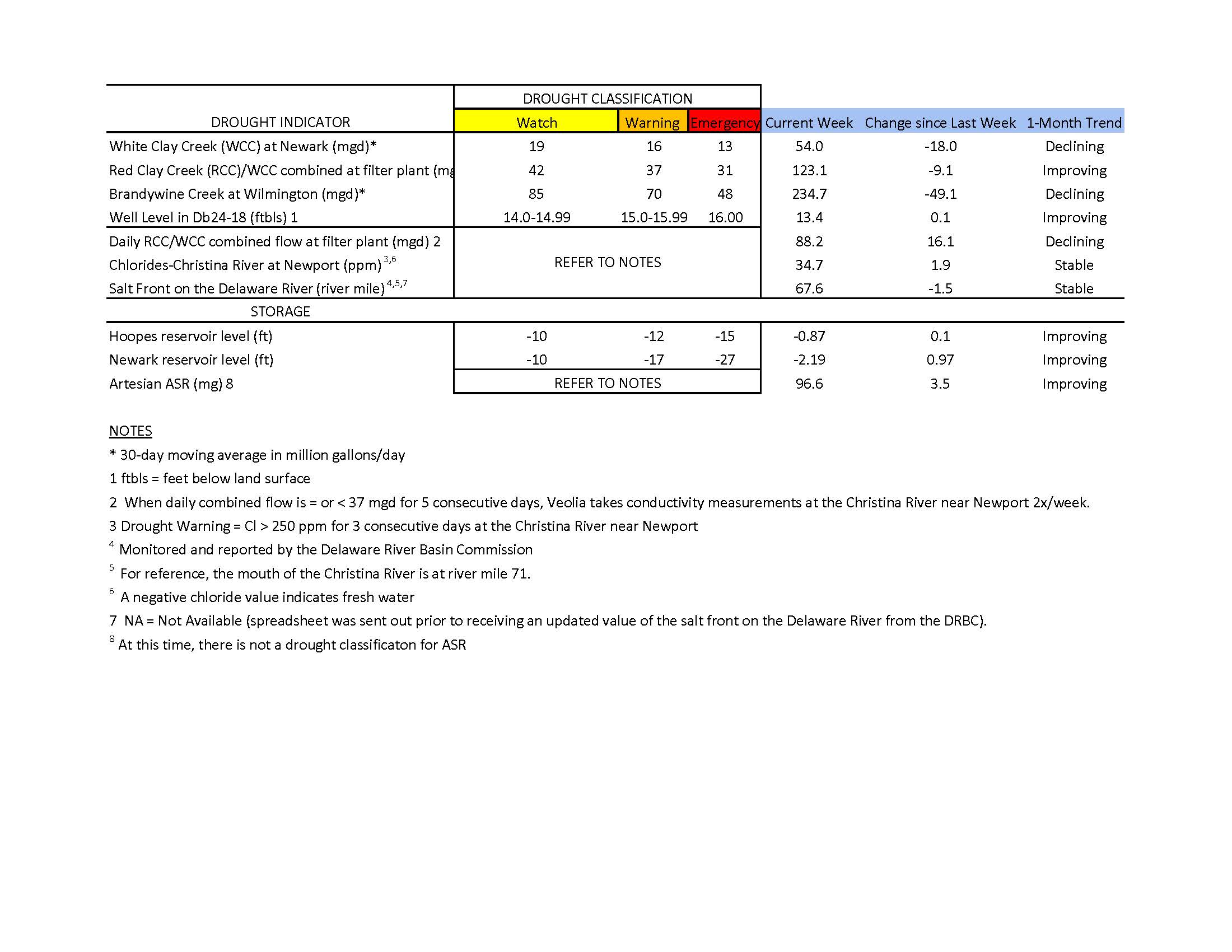
Chloride concentrations in the Christina River near Newport remain well below the first threshold of concern (250 ppm) at approximately 35 ppm. Very fresh water is flowing down the Christina, pushing back any chlorides that may be present. The last time the chloride concentration was above 250 ppm was about seven weeks ago during the first week of March (263.2 ppm). In general, chloride conditions continued to remain low throughout April and into the start of May.
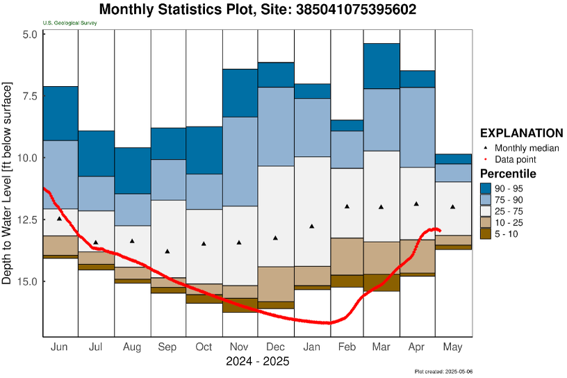
Nearly every long-term groundwater monitoring well in the unconfined aquifer (i.e., surface aquifer) has started to show declining groundwater levels. The exception was well Db24-18 (located just south of Newark), which increased to 13.4 ft below land surface (Table 1). This well is finally above its drought watch threshold but continues to remain approximately one foot below normal. The water level in this well typically ranges between 8.0 and 12.6 feet below land surface during May. After 12 weeks of increasing groundwater levels, USGS well Mc51-01a (located in southwest Kent County) leveled off and then slightly declined in the past week. However, this well is still within the normal range for this time of year (Figure 2).
Overall, groundwater levels are still in good shape, but we will need to see wet conditions return to keep them in their normal range for this time of year.
Weather and Climate Outlook:
Over the next 7 to 10 days, the weather pattern remains somewhat active, with a couple of organized systems moving through our region late this week and next week. Precipitation totals over the next week appear seasonable for this time of year (i.e., approximately 1 inch), which would be an improvement over the last few weeks. Looking at NOAA’s Climate Prediction Center’s outlook for the remainder of May, conditions appear like they’ll remain quite warm for this time of year, which means above normal evapotranspiration rates as well (Figure 3). We’ll need at least normal precipitation for May to avoid going into a surface water deficit this month.