Note: The next drought report will be on November 12th, 2025.
Highlights:
- Precipitation has remained below normal for most of the state over the last 30 to 60 days.
- Soil moisture conditions have continued to decline in September, with most of the state having below normal conditions for this time of year.
- Streamflow conditions have continued to decline for most areas of the state due to the continued water balance deficits in August and September.
- Groundwater conditions are mixed throughout the state, though most monitoring wells are currently in the normal range for this time of year.
- La Nina is expected to develop in the next month or two, which tends to lead to drier and warmer conditions for Delaware during the winter months.
Statewide Drought Discussion
Delaware is currently not experiencing drought conditions, though many areas are drier than normal.
Precipitation
Most of Delaware has experienced below normal precipitation over the last 30 to 60 days. This is particularly the case in northern New Castle and Sussex counties, where precipitation is around 25 to 50 percent of normal (Figure 1).
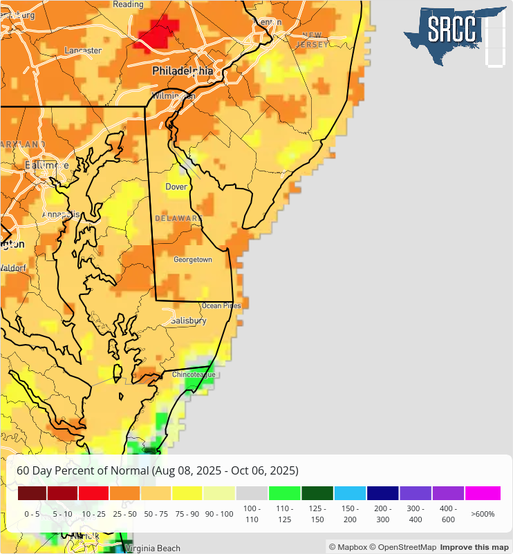
Looking at short-term precipitation, most of Delaware has seen below normal precipitation over the last 30 days (since September 7th). The lone exception is northern Kent County between Dover and Smyrna, which has received between 3 and 3.5 inches of precipitation over that timeframe.
Temperature/Evapotranspiration
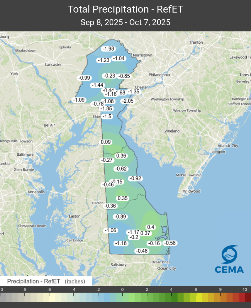
The statewide average reference evapotranspiration over the last 30 days was 3.04 inches, according to DEOS Network data. With statewide average precipitation at 2.32 inches over that same timeframe, the state has run a modest deficit (-0.72”) since September 8th. Figure 2 shows P-ET (precipitation minus reference evapotranspiration) over the last 30 days for the DEOS Network. P-ET was negative (deficit) throughout northern New Castle County, while eastern Sussex saw the greatest positive differences (surplus).
Soil Moisture
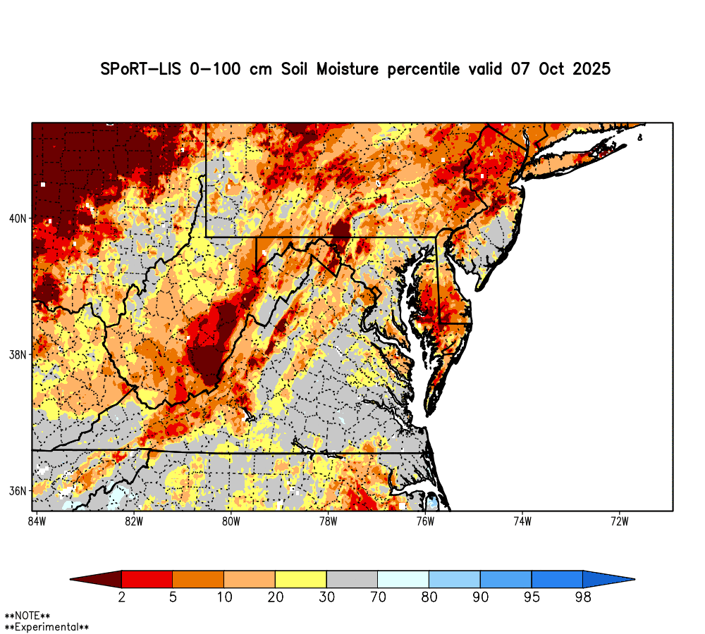
With water balance (i.e., P-ET) deficits continuing from August into September, soil moisture conditions have continued to decline throughout the state. Other than the Middletown-Odessa-Townsend (MOT) area, every location in the state has below normal soil moisture in the top meter of soil for this time of year according to estimates from NASA (Figure 3). The Laurel-Delmar area is particularly low, with most of southwest Sussex County below the 10th percentile.
Streamflow
Dry weather through late summer and early fall has had a noticeable impact on Delaware’s streams. In northern New Castle County, streamflows have been running below normal for more than a month, reaching their lowest sustained levels since December 2024. Unless the state receives a period of steady rain in October, these low-flow conditions are expected to continue.The cooler autumn temperatures have provided some relief by reducing evapotranspiration, which has helped keep conditions from becoming more severe.
Further south, in Kent and Sussex Counties, streamflows are also well below normal, extending a trend that has persisted for several weeks. Continued rainfall through late October and into early winter will be important, particularly in northern Delaware, to help replenish groundwater and prevent the development of drought conditions heading into the winter months.
Chlorides
Chloride levels in the Christina River near Newport have risen above the first threshold of concern (250 ppm), reaching 602 ppm. This is the highest level recorded since November 2024. This shift reflects the influence of lower river flows in recent weeks, which allow tidal saltwater to move farther inland. Without enough rainfall to bring in fresh water and dilute the river, chloride levels are likely to keep climbing. High chloride concentrations accelerate the corrosion of pipes, bridges, and other infrastructure, which can increase maintenance costs and potential failures. In addition, aquatic life in streams like the Christina River and White Clay Creek is sensitive to rising chlorides. Elevated concentrations can stress or harm fish, insects, and plants that rely on fresh water.
For comparison, the typical October median salt front position is around River Mile 72 (about 2 miles north of the mouth of the Christina River), meaning the current location (River Mile 86.1) is noticeably farther upstream than average for this time of year. Continued monitoring through the fall will help assess whether upcoming rainfall and river discharge push the salt front back downstream toward its usual seasonal position.
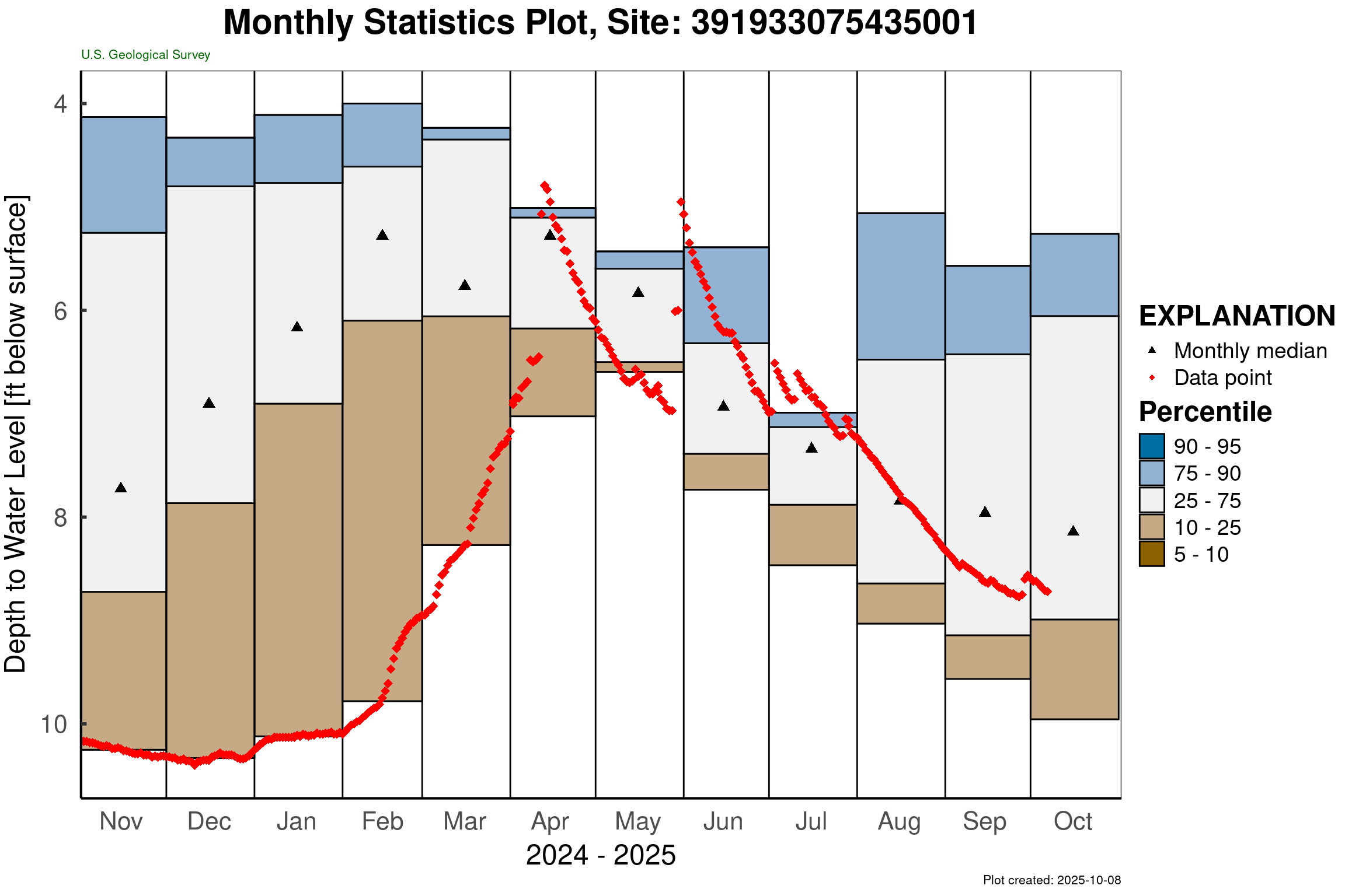
Groundwater
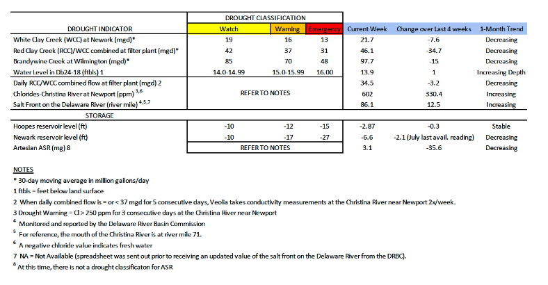
Groundwater levels across Delaware showed mixed conditions in October, reflecting the effects of several dry months. In northern New Castle County, water levels in the unconfined (shallow) aquifer have continued to decline. A monitoring well just south of Newark (Db24-18) measured 13.9 feet below land surface, which is near the low end of the normal range for this time of year (typically 12.3 to 14.4 feet below land surface).
Elsewhere in the state, groundwater conditions vary. A well in southern New Castle County (Hb12-05) remains close to its average October level (Figure 4), while a well in southwestern Kent County (Mc51-01a) has been declining steadily since late April and is now below the 5th percentile, indicating much lower-than-normal conditions. In southeastern Sussex County, the well Pf24-02 has remained within the normal range since May, with a brief period of above-normal levels in early August.
Low groundwater levels—such as those observed in parts of Kent County—can put stress on local water supplies and increase the potential for shortages if dry weather continues into the winter months. Continued monitoring will help track whether recharge improves with late fall and winter precipitation.
Weather and Climate Outlook
The Seasonal Drought Outlook from NOAA’s Climate Prediction Center (CPC) does not show drought developing in Delaware or the Delmarva Peninsula over the October to December timeframe. This is despite a 71% chance of La Nina developing sometime in the next couple of months (Figure 5).
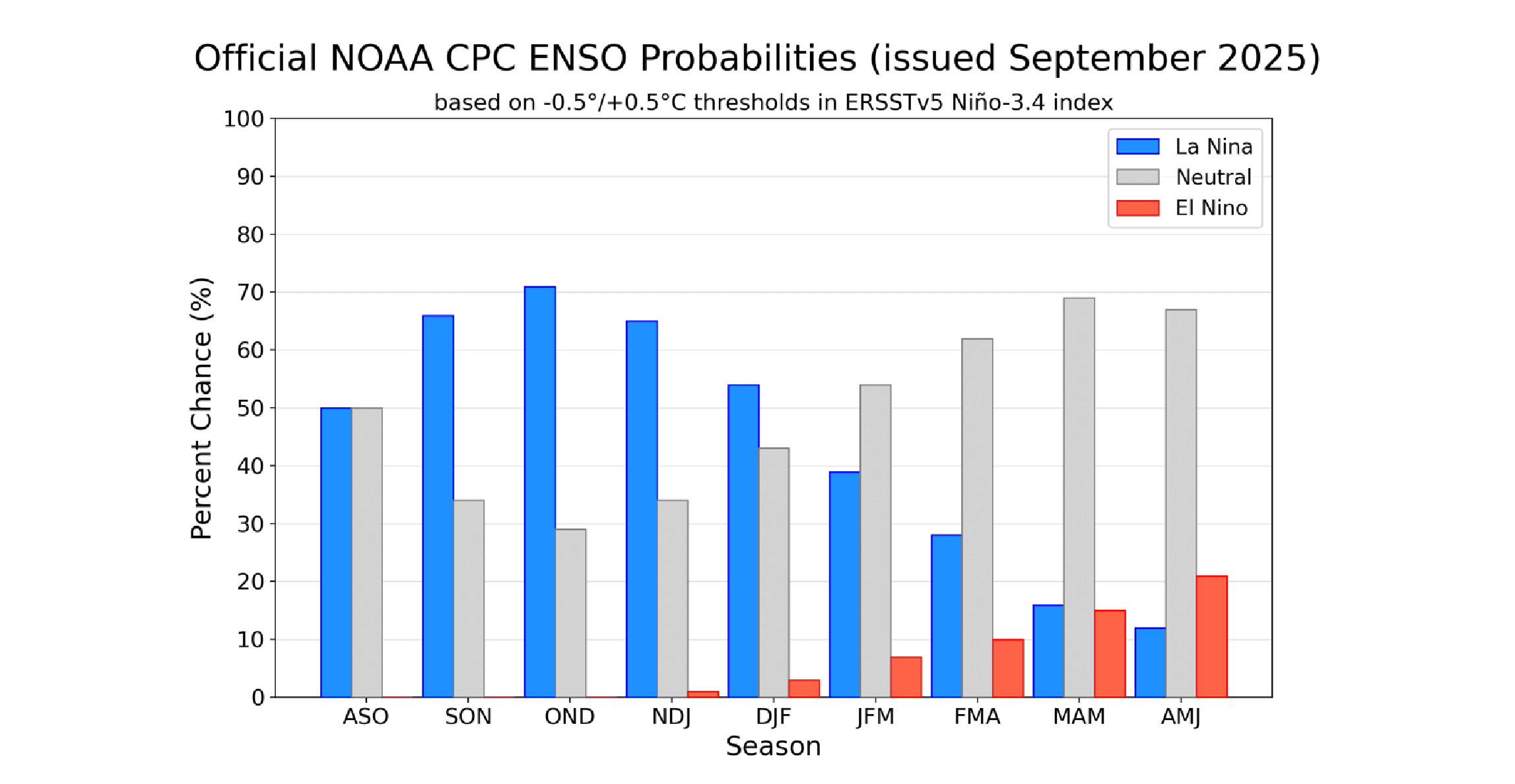
Wintertime La Nina episodes generally lead to slightly below normal precipitation and above normal temperatures for Delaware, though this tendency can be affected by the intensity of the La Nina. Weaker La Nina’s, like the one forecast to develop this fall and winter, are less predictable in terms of how they’ll affect temperature and precipitation for the Mid-Atlantic region. That said, this climate pattern certainly bears watching since it can have a significant impact on the weather patterns we experience.