Below normal temperatures and heavy snowfall characterized Delaware’s Climate during the 2013-2014 winter season.
Winter Temperatures
Preliminary data indicates that Delaware’s winter temperature was below the 1981-2010 normal for the third time in the last five years. The Statewide mean winter temperature of 34.9°F was 1.4°F below the 30-year normal of 36.3°F. Although slightly cooler than normal, this winter’s temperature was actually near the middle of all winters since records began in 1895 (Figure 1).
Winter Precipitation
Cold temperatures were accompanied by above normal precipitation across the state during the winter season. The statewide mean precipitation of 12.35” was 2.59” above the 1981-2010 normal of 9.76”, and was the first winter since 2009-2010 with above normal values (Figure 2), and the 18th wettest winter since records began in 1895.
Statewide Spatial Averages
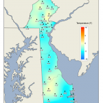
Data from the Delaware Environmental Observing System (DEOS) show that mean winter temperatures across the state were cold throughout, with the coldest conditions found along coastal Sussex County and in sections of northern Kent and southern New Castle Counties (Figure 3). The spatial patterns of average maximum (Figure 4) and minimum (Figure 5) temperatures were similar to that of the mean winter temperature across the First State.
The colder than normal temperatures, combined with above normal precipitation resulted in heavy snowfall totals across the entire State during the 2013-2014 snowfall season. More than twice the seasonal average fell across the entire state with some locations receiving nearly three times their average accumulations. Snowfall totals ranged from over 50 inches in northern New Castle County and Chester County, PA to greater than 25 inches across extreme southern portions of Delaware.
-
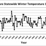
- Figure 1. Delaware statewide mean Winter temperature (°F) 1896-2014.
-
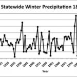
- Figure 2. Delaware statewide Winter precipitation (inches) 1896-2014.
-
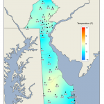
- Figure 3. Winter 2014 average temperature departures from the 1981-2010 mean based upon DEOS station data.
-
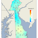
- Figure 4. Winter 2014 mean maximum temperature departures from the 1981-2010 mean based upon DEOS station data
-
- Figure 5. Winter 2014 mean minimum temperature departures from the 1981-2010 mean based upon DEOS station data
-
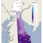
- Figure 6. November 2013 through March 2014 snowfall totals based upon DEOS station data.
Similar Posts
- February 2026 – Cold with Near Normal Precipitation Across Delaware (2026)
- January 2026 – Cold with Near Normal Precipitation Across Delaware (2026)
- December 2025 – Cold and Dry Across Delaware (2026)
- February 2025 – Cool with Near Normal Precipitation Across Delaware (2025)
- January 2025 – Very Cold and Very Dry Across Delaware (2025)
Climate Office Partners


