Annual Temperatures
Statewide mean annual temperature in 2015 was 56.4°F according to preliminary data from the National Climatic Data Center (NCDC). This was 1.0°F above the 1981-2010 normal of 55.4°F (Figure 1) and was the 11th warmest year in Delaware since 1895.
Monthly temperatures varied greatly throughout the year (Figure 2). The first three months of 2015 saw much below normal temperatures, including the 6th coldest February since 1895. The last nine months of the year saw above normal temperatures, except for October, which was slightly below normal. Tremendous warmth ended the year with December temperatures averaging 12.4°F above the 1981-2010 mean. December 2015 was the warmest December on record, smashing the old record by 6.1°F.
Annual Precipitation
Statewide precipitation in 2015 averaged 46.37 inches, 2.04 inches above the 1981-2010 mean of 44.33 inches (Figure 3).
Monthly precipitation anomalies varied between positive and negative throughout the year, with seven months of below normal and five months of above normal precipitation (Figure 4). June saw the largest precipitation anomaly of 5.30 inches above the 30-year normal, helping to push the annual value above the long-term mean.
Statewide Spatial Averages
According to data from the Delaware Environmental Observing System (DEOS; deos.udel.edu), mean annual temperature anomalies varied across Delaware (Figure 5). Northern New Castle County, much of Sussex County, southern Kent County and Chester County, PA all experienced above normal temperatures for the year. Coastal Sussex County and western portions of News Castle and Kent counties saw below normal mean annual temperatures.
Precipitation across the region varied substantially in 2015, ranging from just under 40 inches to greater than 50 inches at several locations across the State (Figure 6).
-
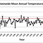
- Figure 1. Delaware statewide annual mean temperature (°F) 1895-2015. Red line indicates 1981-2010 normal.
-
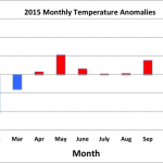
- Figure 2. Delaware 2015 monthly temperature anomalies.
-
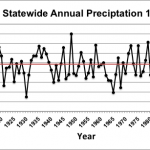
- Figure 3. Delaware statewide annual precipitation (inches) 1895-2015. Red line indicates 1981-2010 normal.
-
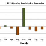
- Figure 4. Delaware 2015 monthly precipitation anomalies.
-
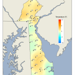
- Figure 5. 2015 mean annual temperature departures from the 1981-2010 mean based upon DEOS station data.
-
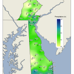
- Figure 6. 2015 annual precipitation totals based upon DEOS station data.
Similar Posts
- June 2026 – Warm and Dry Across Delaware (2026)
- May 2026 – Continued Dry Across Delaware (2026)
- April 2026 – Very Warm and Dry Across Delaware (2026)
- March 2026 – Very Warm with Below Normal Precipitation Across Delaware (2026)
- February 2026 – Cold with Near Normal Precipitation Across Delaware (2026)
Climate Office Partners


