June Temperatures
Preliminary data indicates that the statewide average temperature in June was 72.7°F, which is 0.6°F above the 1981-2010 mean value of 72.1°F (Figure 1). June 2018 was the 26th warmest June since 1895. While a large majority of the United States saw significantly above normal temperatures for June (Figure 2), Delaware’s temperatures were more consistent with temperature anomalies found across the mid-Atlantic and New England.
June Precipitation
Delaware’s statewide precipitation for June 2018 averaged 3.62 inches, 0.11 inches below the 1981-2010 mean (Figure 3). However, the year-to-date precipitation across Delaware continues to run above normal, with precipitation during the first six months of the year coming in as the 16th wettest since 1895, and the wettest since 2003, mainly as a result of heavy precipitation during February and May.
Statewide Spatial Averages
Data from the Delaware Environmental Observing System (DEOS)
show that temperature (Figure 4) departures were generally small and varied between positive and negative values across the State. This pattern of departures is expected for a month with near normal
temperature conditions. Precipitation departures also varied greatly from one location to another (Figure 5). This is due to the “convective nature” of the precipitation during the summer months, with most falling in thunderstorms that cover only a small area.
-
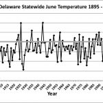
- Figure 1. Delaware statewide mean June temperature (°F) 1895-2018. Gray line indicates 1981-2010 normal.
-
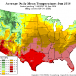
- Figure 2. National daily mean temperature anomalies for June 2018 (from the PRISM Climate Group, OSU).
-
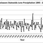
- Figure 3. Delaware statewide June precipitation (inches) 1895-2018. Gray line indicates 1981-2010 normal.
-
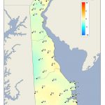
- Figure 4. June 2018 average temperature departures (°F) from the 1981-2010 mean based upon DEOS station data.
-
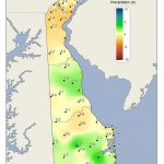
- Figure 5. June 2018 precipitation departures (inches) from the 1981-2010 mean based upon DEOS station data.
Similar Posts
- June 2026 – Warm and Dry Across Delaware (2026)
- June 2025 – Very Warm with Below Normal Precipitation Across Delaware (2025)
- June 2024 – Continued Warm with Near Normal Precipitation (2024)
- June 2023 – Cool with Variable Precipitation Across Delaware (2023)
- June 2022 – Near Normal Temperature and Precipitation Across Delaware (2022)
Climate Office Partners


