June Temperatures
Preliminary data indicates that the statewide average temperature in June was 74.5o F, which is 1.9o F above the 1991-2020 average value of 72.6o F (Figure 1). June 2026 was the 7th warmest June since observations began in 1895. At the Wilmington, Dover, and Georgetown Airports (Figures 2a, 2b, 2c), the month began with very warm temperatures featuring highs in the 90s at each station on the 4th and 5th. A second heatwave gripped the state on the 11th and 12th as all three stations reached daily high temperatures in the mid-to-upper 90s.
June Precipitation
Delaware’s statewide precipitation for June 2026 averaged 2.83 inches, 1.26 inches below the 1991-2020 average of 4.09 inches (Figure 3). June 2026 was tied with 1950 as the 42nd driest June since observations began in 1895. June was also the 11th month in a row with at or below normal precipitation across Delaware.
Statewide Spatial Anomalies
Data from the Delaware Environmental Observing System (DEOS) show that temperatures varied depending upon location across the State, with most stations seeing positive departures of 1o – 2o F (Figure 4). Precipitation was uniformly below normal across New Castle and Kent counties, while some locations across Sussex County experienced slightly positive precipitation departures (Figure 5).
National Anomalies
Temperatures were above or near normal across all of the United States except eastern portions of Montana (Figure 6). The largest positive temperature anomalies were found across the southwestern portions of the country. Precipitation was significantly above normal across much of the Mississippi Valley (Figure 7), while large negative precipitation anomalies dominated much of the Atlantic Coast. In general, the western one-third of the country saw precipitation near or just below normal.
Global Anomalies
June 2026 was the 2nd warmest June on record for the globe since 1850. Global temperatures were 1.96o F above the 1901-2000 mean. Of particular note this month were the record warm temperatures across most of Europe. Western Asia and Canada also saw very warm conditions during the month (Figure 8).
-
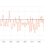
- Figure 1. Delaware statewide mean June temperature (degrees F) 1895-2026. The black line indicates the 1991-2020 average (NOAA, NCEI, Climate at a Glance: Statewide Time Series).
-
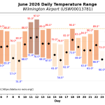
- Figure 2a. Mean daily temperature, high temperature, and low temperature (degrees F) for Wilmington (RCC ACIS https://data.rcc-acis.org/).
-
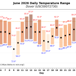
- Figure 2b. Mean daily temperature, high temperature, and low temperature (degrees F) for Dover (RCC ACIS https://data.rcc-acis.org/).
-
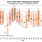
- Figure 2c. Mean daily temperature, high temperature, and low temperature (degrees F) for Georgetown (RCC ACIS https://data.rcc-acis.org/).
-
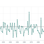
- Figure 3. Delaware statewide June precipitation (inches) 1895-2026. The Black line indicates the 1991-2020 average (NOAA, NCEI, Climate at a Glance: Statewide Time Series).
-
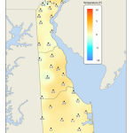
- Figure 4. June 2026 average temperature departures (degrees F) from the 1991-2020 mean based upon DEOS station data.
-
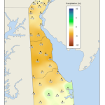
- Figure 5. June 2026 precipitation departures (inches) from the 1991-2020 mean based upon DEOS station data.
-
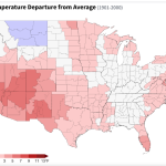
- Figure 6. United States climate division temperature anomalies (degrees F) for June 2026 (NOAA, NCEI, Climate at a Glance: Divisional Mapping).
-
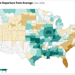
- Figure 7. United States climate division precipitation anomalies (inches) for June 2026 (NOAA, NCEI, Climate at a Glance: Divisional Mapping).
-
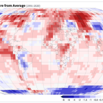
- Figure 8. Global temperature anomalies (degrees C) for June 2026 (NOAA, NCEI, Climate at a Glance: Global Mapping).
Similar Posts
- June 2025 – Very Warm with Below Normal Precipitation Across Delaware (2025)
- June 2024 – Continued Warm with Near Normal Precipitation (2024)
- June 2023 – Cool with Variable Precipitation Across Delaware (2023)
- June 2022 – Near Normal Temperature and Precipitation Across Delaware (2022)
- June 2021 – Warm and Dry Across Delaware (2021)
Climate Office Partners