August Temperatures
Preliminary data indicates that the statewide average temperature in August was 77.9o F, which was 2.4o F above the 1991-2020 average value of 75.5o F (Figure 1). August 2026 was tied with August 2005 as the 6th warmest August since observations began in 1895. At the Wilmington, Dover, and Georgetown Airports (Figure 2a, 2b, 2c), the month began with very warm temperatures featuring highs 90o F or above at each station on the 6th through the 10th. A second heatwave impacted the state from the 18th through the 20th as all three stations reached daily high temperatures between the upper 80s and low 90s.
August Precipitation
Delaware’s statewide precipitation for August 2026 averaged 6.57 inches, 1.88 inches above the 1991-2020 average of 4.69 inches (Figure 3). August 2026 was tied with August 1992 as the 23rd wettest August since observations began in 1895.
Statewide Spatial Anomalies
Data from the Delaware Environmental Observing System (DEOS) show that temperatures varied depending upon location across the State, with southern Kent and Sussex Counties seeing the largest positive temperature anomalies (Figure 4). Precipitation across the State was highly variable due to thunderstorm rainfall (Figure 5). Many stations saw positive precipitation anomalies, some of greater than 2 inches during the month, while other stations recorded less than normal precipitation for August.
National Anomalies
Temperatures were near or above normal across all of the continental United States except for a single climate division in North Dakota (Figure 6). The largest positive temperature anomalies were found across portions of Arizona, New Mexico, and Texas. Precipitation varied greatly across the country due to the convective nature of summer season rainfall (Figure 7). Eastern portions of Texas, Oklahoma, and Kansas saw very dry conditions, while the Mid-Atlantic and the upper Midwest saw much above normal precipitation.
Global Anomalies
August 2026 was the warmest August on record for the globe since 1850. Global temperatures were 2.38o F above the 1901-2000 mean. Of particular note this month were the very warm temperatures across most of North America, Western Europe, the central equatorial Pacific, and much of Africa (Figure 8).
-
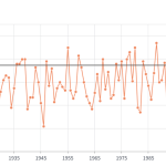
- Figure 1. Delaware statewide mean August temperature (degrees F) 1895-2026. The black line indicates the 1991-2020 average (NOAA, NCEI, Climate at a Glance: Statewide Time Series).
-
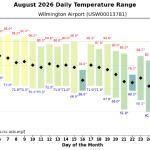
- Figure 2a. Mean daily temperature, high temperature, and low temperature (degrees F) for Wilmington (RCC ACIS https://data.rcc-acis.org/).
-
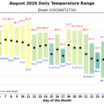
- Figure 2b. Mean daily temperature, high temperature, and low temperature (degrees F) for Dover (RCC ACIS https://data.rcc-acis.org/).
-
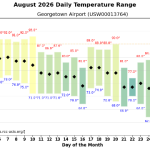
- Figure 2c. Mean daily temperature, high temperature, and low temperature (degrees F) for Georgetown (bottom) (RCC ACIS https://data.rcc-acis.org/).
-
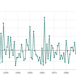
- Figure 3. Delaware statewide August precipitation (inches) 1895-2026. The Black line indicates the 1991-2020 average (NOAA, NCEI, Climate at a Glance: Statewide Time Series).
-
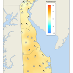
- Figure 4. August 2026 average temperature departures (degrees F) from the 1991-2020 mean based upon DEOS station data.
-
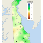
- Figure 5. August 2026 precipitation departures (inches) from the 1991-2020 mean based upon DEOS station data.
-
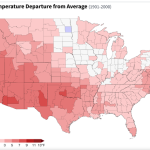
- Figure 6. United States climate division temperature anomalies (degrees F) for August 2026 (NOAA, NCEI, Climate at a Glance: Divisional Mapping).
-
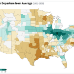
- Figure 7. United States climate division precipitation anomalies (inches) for August 2026 (NOAA, NCEI, Climate at a Glance: Divisional Mapping).
-
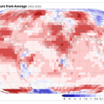
- Figure 8. Global temperature anomalies (degrees C) for August 2026 (NOAA, NCEI, Climate at a Glance: Global Mapping).
Similar Posts
- August 2025 – Very Cool with Below Normal Precipitation Across Delaware (2025)
- August 2024 – Dry with Near Normal Temperature (2024)
- August 2023 – Warm with Below Normal Precipitation Across Delaware (2023)
- August 2022 – Warm and Dry Conditions Persist Across Delaware (2022)
- August 2021 – Continued Warm and Wet Across Delaware (2021)
Climate Office Partners