Week of May 20th, 2026
Posted on May 21, 2026Note: The next drought report will be on June 17th, 2026
Highlights:
- Precipitation continues to lag statewide. Our last above normal month was July 2026.
- Spring temperatures have been above normal, which is increasing the demand for water from vegetation and the environment in general.
- Streamflows at numerous stream gauges across the state are considerably below normal, with some locations experiencing their lowest levels ever for this time of year.
- Well levels continue to decline as result of the long-term, below normal precipitation conditions
- The outlook for June doesn’t look favorable for much recovery from the current drought, as temperatures are likely to remain seasonably warm and precipitation not likely to be above normal.
Statewide Drought Discussion
Nine consecutive months of below normal precipitation and a warm start to the spring has pushed streamflows to extremely low levels for this time of year at some stream gauges in Delaware. Well levels are beginning to decrease throughout Delaware as the weather warms and evapotranspiration rates increase.
Precipitation
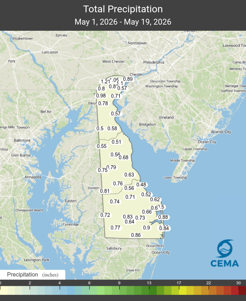
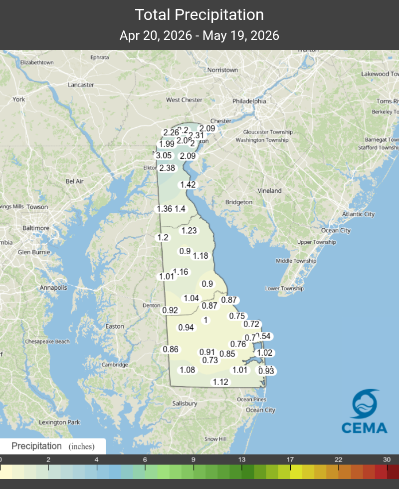
April 2026 marked the ninth straight month with below normal precipitation for the state (relative to 1991-2020 base period). As Figure 1 shows, May hasn’t fared any better. The statewide average May precipitation from 1991-2020 is 3.58 inches. To date, the statewide average precipitation total in the DEOS Network is 0.74 inches. We’ll need a considerable amount of rain the remainder of the month to break our streak of below normal precipitation months.
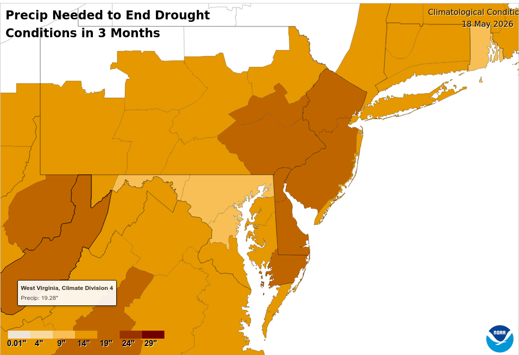
Because of this extended deficit, NCEI’s drought recovery and amelioration tool (Figure 2) shows that over the next 3 months, Delaware would need approximately 21 inches, or 9 to 10 inches above normal, to end the drought, based on the Palmer Hydrologic Drought Index (PHDI). The PHDI is useful for looking at long-term drought conditions, which is what Delaware is experiencing right now. Additionally, the probability of receiving this much rain over the next three months, based on historical conditions, is about 2%. These are obviously not great odds and are certainly cause for concern.
Temperature/Evapotranspiration
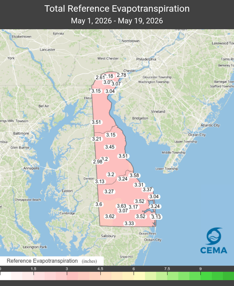
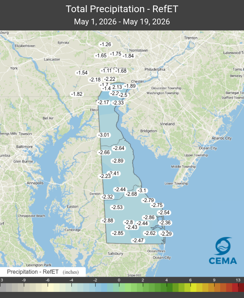
The spring of 2026 has begun on a warm note, which means more loss of water from the soil through evapotranspiration. Figure 3 shows the amount of estimated reference evapotranspiration stations in the DEOS Network have experienced since May 1. This is followed by Figure 4, which shows the water balance deficit that has occurred in just 19 days for stations across the DEOS Network.
Short-term forecasts suggest that our temperature over the next several days will be unseasonably cool. Assuming this happens, we should expect our evapotranspiration rates to become somewhat lower and temporarily keep drought conditions from becoming worse.
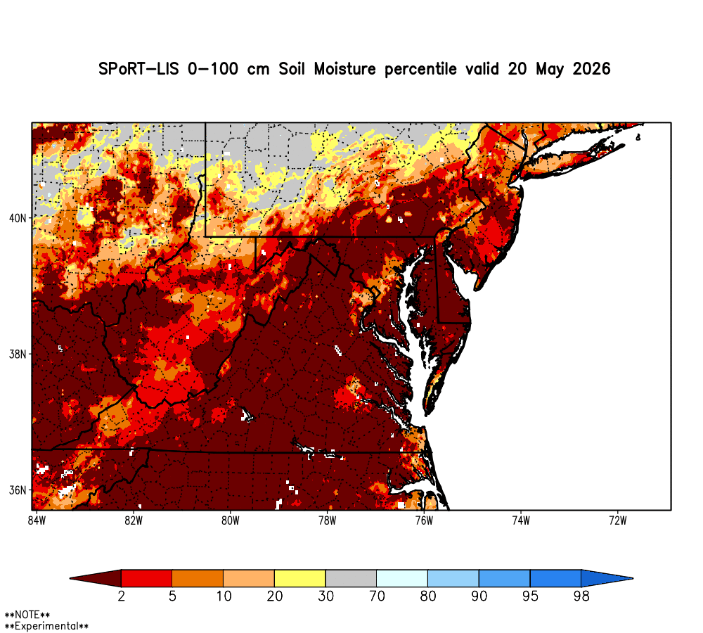
Soil Moisture
Soil moisture in Delaware, and most of the Mid-Atlantic region, has dropped well below the average value for this time of year (Figure 5). Percentiles for most of Delaware are below the 2nd percentile. Meanwhile, some portions of northern New Castle County have a little bit more soil moisture, though this part of the state is still in the 10th to 20th percentile. These low soil moisture percentile values indicate that Delaware is experiencing extremely low soil moisture conditions just about statewide.
Streamflow
The sustained three-month decline in Delaware’s streams is not just a seasonal fluctuation; it is a clear hydrological anomaly. Spring is typically the peak recharge period for streams in the Mid-Atlantic, which is driven by winter snowmelt and a peak in precipitation relative to other parts of the year. Added to the lack of precipitation is the fact that the streams did not fully recover from the low flows that occurred in the fall of 2025. When streamflow drops steadily over a three-month spring window, the resulting shallow depths and reduced water velocities can lead to elevated water temperatures and physical obstacles, which could impact the local fish habitat.
In northern New Castle County, by mid-spring, the flows on White Clay Creek, Red Clay Creek, and Brandywine Creek at Wilmington dropped into the bottom 5th to 10th percentile range. This means that for this specific time of year, the flows are “much below normal” and are encountered less than 10% of the time in our recorded history.
In Kent County, the St. Jones River at Dover has maintained flow in the below normal range (10th – 25th percentile) with a few exceptions in the normal range. However, the Nanticoke River at Bridgeville dropped into the critical <5th percentile tier during the winter and early spring before marginally recovering to the 5th-to-10th percentile. Normal flows for all streams in the state should be between the 25th and 75th percentiles.
These sustained low-flow conditions pose significant risks to aquifer recharge and water quality parameters. To transition these systems back to seasonal norms, the state needs a sustained period of significant, above-normal precipitation over the next 60 days to offset current deficits.
Chlorides
One of the most definitive indicators of a regional drought is the behavior of the Delaware River salt front—the interface where salty ocean water meets fresh river water; however, the specific conductance (a proxy for chloride) readings at the Christina River at Newport have remained quite low since March. The most recent reading resulted in a calculated chloride concentration of approximately 48 parts per million, which is much lower than the secondary maximum contamination level of 250 ppm.
This should not be taken as a sign that hydrologic conditions aren’t serious. Even though the flows on the tributaries are very low, the water at the gage at Newport is being kept fresh by a continuous flow of freshwater coming down the mainstem Delaware River.
Groundwater
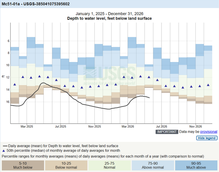
Streamflow is tied to the water table, and like streams, spring is the time of year that the shallow, unconfined aquifer should be recharging. Near Newark, this aquifer as measured in well Db24-18, dropped to over 14.5 feet below the land surface (fbls), which exceeds the typical spring average of 8 to 12.7 fbls. A substantial amount of precipitation will be necessary for the water level in this well to recharge 1.8 ft, which will only bring this water level to the very low end of normal for this time of year. A critical USGS/DGS monitoring well in southwestern Kent County (Mc51-01a) has consistently been tracking below the 5th percentile, which has the potential to be a record low for this well. In May, the normal water level in this well is between 10.3 and 12.7 fbls; however, the current water level is at 15.5 fbls, which is extremely below normal (Figure 6).
At least one well (Pf24-02 located south of Georgetown) remained within the normal range, reflecting geographic variability in groundwater response across Delaware.
Delaware’s groundwater system responds slowly to changes in precipitation compared with surface waters (like streams and rivers). As a result, patterns of dry weather tend to show up first in streamflow and soil moisture, and then, if dry conditions persist, in groundwater levels and aquifer conditions.
Groundwater is a major source of drinking water and irrigation supply in much of Delaware, especially south of the Chesapeake and Delaware Canal. Extended periods of low levels can reduce well yields and may require deeper pumping or alternative supply strategies in some communities. Persistently low groundwater levels increase the risk of saltwater intrusion in coastal and near-estuarine aquifers, complicating long-term freshwater sustainment. In addition, low groundwater can stress wetlands and baseflow conditions to streams during dry periods, affecting fish, invertebrates, and riparian habitats.
Weather and Climate Outlook
With drought conditions upon us, we want to focus on weather at the seasonal to sub-seasonal scale. NOAA’s CPC has provided its latest update for June temperature and precipitation (Figures 7 and 8).
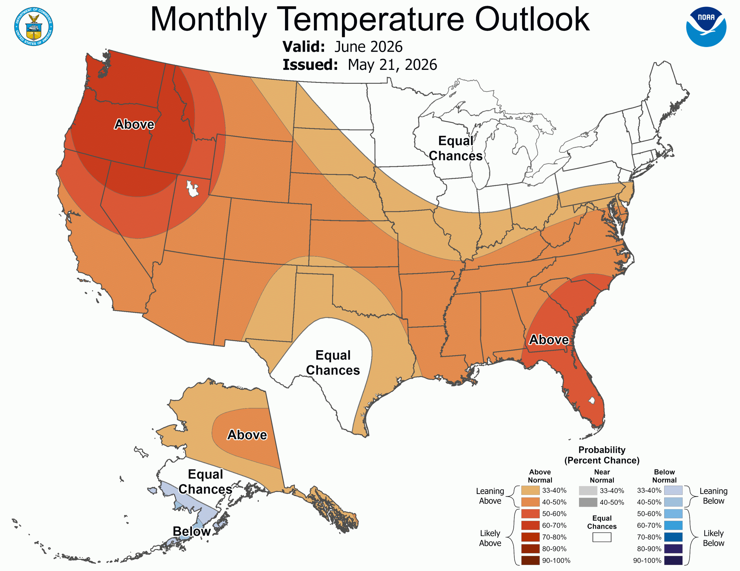
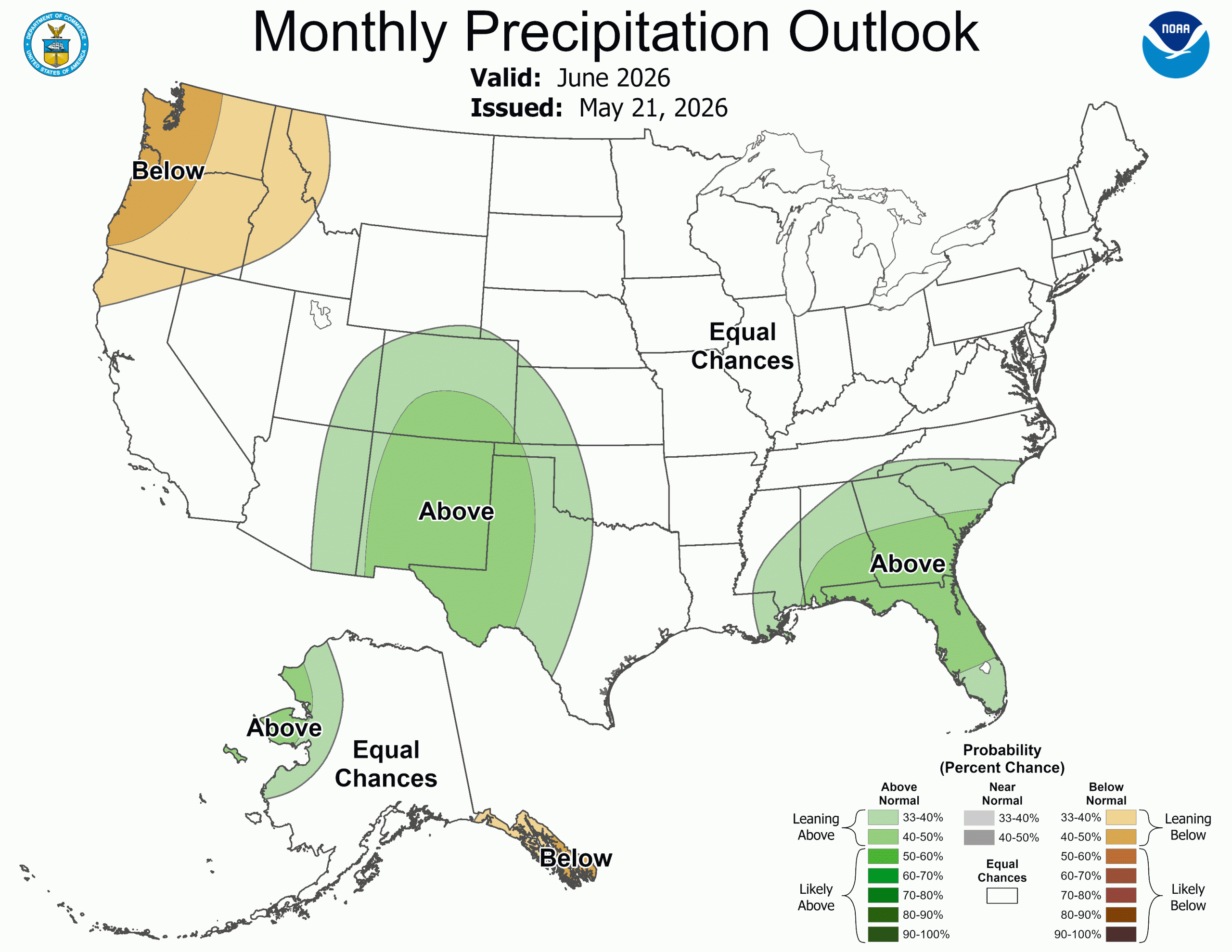
Unfortunately, the prospects aren’t great. Above normal temperatures would indicated increased evapotranspiration, thus we’ll see an even greater demand for water from the environment than if we would under normal conditions. Precipitation has equal chances of being above or below normal, so there’s not much to use there. One thing to note in Figure 8 is the above normal precipitation probabilities in the southern tier of the country. This pattern is more common during El Nino conditions, which we are transitioning into over the summer. While El Nino’s effect is typically pretty minimal on Delaware’s weather during the summer months, it would give us a more predictable climate pattern to key off of in the cooler months later this year.

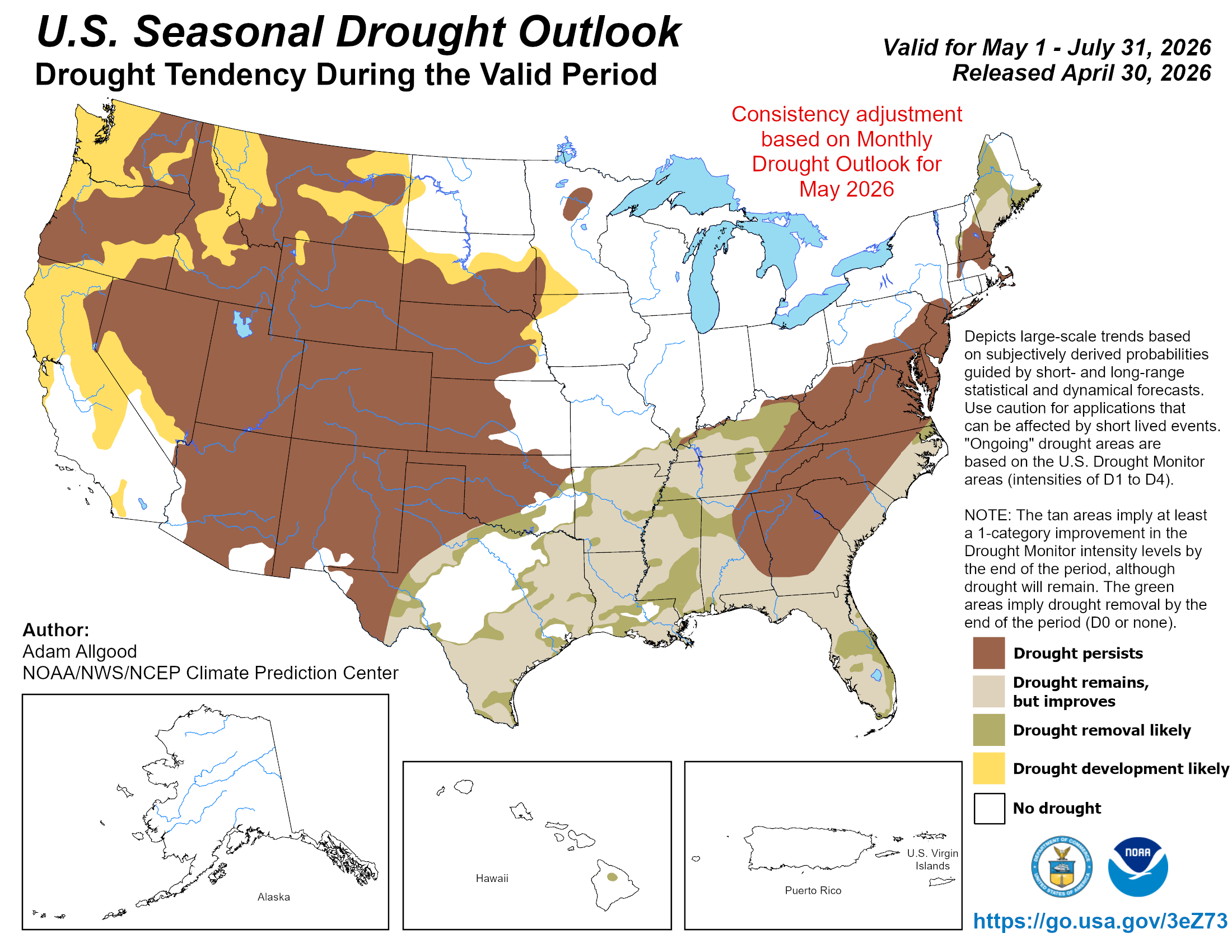
US Seasonal Drought Outlook map released on April 16, 2026. Source: Adam Allgood, NOAA/NWS/NCEP Climate Prediction Center; url: https://www.cpc.ncep.noaa.gov/products/expert_assessment/season_drought.png
Delaware Drought Status
Watch
Resources
- Delaware Water Tracker
- DGS Water Conditions Report
- US Drought Monitor
- NOAA Climate at a Glance
- Drought.gov DE site
- DE Water Supply Coordinating Council
- DRBC Drought Dashboard
- Surrounding State Pages:
Climate Office Partners


