Drops of water on bright green grass

Temperature and Precipitation Both Above Normal Across Delaware During 2015


Annual Temperatures

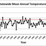
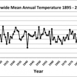
Statewide mean annual temperature in 2015 was 56.4°F according to preliminary data from the National Climatic Data Center (NCDC). This was 1.0°F above the 1981-2010 normal of 55.4°F (Figure 1) and was the 11th warmest year in Delaware since 1895.

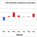
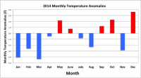
Monthly temperatures varied greatly throughout the year (Figure 2). The first three months of 2015 saw much below normal temperatures, including the 6th coldest February since 1895. The last nine months of the year saw above normal temperatures, except for October, which was slightly below normal. Tremendous warmth ended the year with December temperatures averaging 12.4°F above the 1981-2010 mean. December 2015 was the warmest December on record, smashing the old record by 6.1°F.

Annual Precipitation

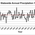
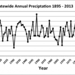
Statewide precipitation in 2015 averaged 46.37 inches, 2.04 inches above the 1981-2010 mean of 44.33 inches (Figure 3).

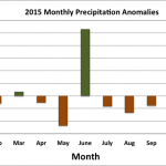
Monthly precipitation anomalies varied between positive and negative throughout the year, with seven months of below normal and five months of above normal precipitation (Figure 4). June saw the largest precipitation anomaly of 5.30 inches above the 30-year normal, helping to push the annual value above the long-term mean.

Statewide Spatial Averages

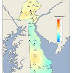
According to data from the Delaware Environmental Observing System (DEOS; deos.udel.edu), mean annual temperature anomalies varied across Delaware (Figure 5). Northern New Castle County, much of Sussex County, southern Kent County and Chester County, PA all experienced above normal temperatures for the year. Coastal Sussex County and western portions of News Castle and Kent counties saw below normal mean annual temperatures.

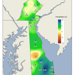
Precipitation across the region varied substantially in 2015, ranging from just under 40 inches to greater than 50 inches at several locations across the State (Figure 6).

Images
Trees in Autumn

Autumn 2014 Slightly Dry with Near Normal Temperatures Across Delaware

Autumn Temperatures

de_statewideAutumnTemp-1895-2014_0.png
Figure 1. Delaware Statewide mean Autumn Temperature (°F) 1895-2014.

Preliminary data indicates that the statewide mean autumn temperature of 57.8°F was 0.2°F above the

1981-2010 normal of 57.6°F (Figure 1). The near normal autumn temperatures followed four consecutive seasons with below normal temperatures across Delaware. Temperatures

de_monthlyTempAnom_2014.png
Figure 2. Delaware statewide temperature anomalies for January 2014 through November 2014.

have been quite variable across the State during the year (Figure 2), with seven of the first eleven months being below normal.

Autumn Precipitation

Near normal autumn temperatures were accompanied by slightly dry conditions across the state during the autumn season. The statewide

de_statewideAutumnPrecip-1895-2014_0.png
Figure 3. Delaware Statewide mean Autumn Precipitation (°F) 1895-2014.

mean precipitation of 9.52 inches was 1.31 inches below the 1981-2010 normal of 10.83 inches (Figure 3). Monthly precipitation anomalies have varied between positive and negative during the year, but

no month has seen large departures from normal (Figure 4).

de_monthlyPrecipAnom_2014_0.png
Figure 4. Delaware statewide precipitation anomalies for January 2014 through November 2014.

Statewide Spatial Averages

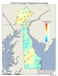
Data from the Delaware Environmental Observing System (DEOS) show that temperatures varied considerably across the State during the autumn season (Figure 5), with generally small positive or negative departures at most stations. The largest departures were found along the coastal areas of Sussex County where cool conditions were dominant.

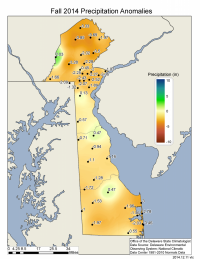
Precipitation varied from as low as 7.51 inches along the Atlantic Coast to a high of 14.52 inches in western Chester County, PA. Even with this large variation, most stations in the region experienced slightly dry conditions during the season, with the greatest negative anomalies found along the Atlantic Coast and in northern Chester County, PA (Figure 6).

Autumn 2014 average temperature departures
Figure 5. Autumn 2014 average temperature departures from the 1981-2010 mean based upon DEOS station data.
Autumn 2014 precipitation departures
Figure 6. Autumn 2014 precipitation departures from the 1981-2010 mean based upon DEOS station data.
Autumn Leaves

Delaware Climate Near Normal During October 2015

Delaware experienced near normal temperature and precipitation conditions during October 2015. Although the monthly averages were near normal, an early October weather system brought strong winds, and coastal flooding to much of the State.

de_statewideOctTemp-1895-2015_0.png

Figure 1. Delaware statewide mean October temperature (°F) 1895-2015.
de_statewideOctPrecip-1895-2015_0.png

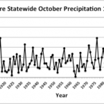
Figure 2. Delaware statewide mean October precipitation (inches) 1895-2015.

October Temperatures

Preliminary data indicates that the statewide average temperature in October was 56.6°F, 0.5°F below the 1981-2010 normal of 57.1°F (Figure 1). October 2015 was the coolest since 2009.

October Precipitation

Delaware’s preliminary statewide precipitation total for October 2015 averaged 3.49 inches, just 0.03 inches above the 1981-2010 mean (Figure 2).

Statewide Spatial Averages

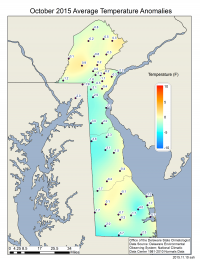
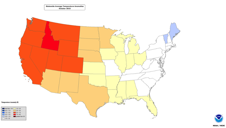
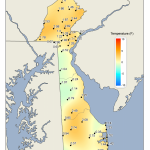
Most Delaware Environmental Observing System (DEOS) stations saw temperatures slightly below normal for the month (Figure 3). Like Delaware, much of the eastern portion of the United States had near normal temperatures during the month, while the western United States was much warmer than average (Figure 4).

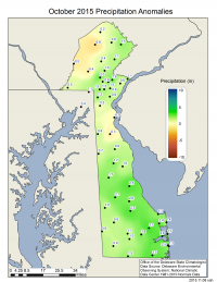
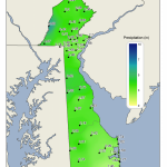
Precipitation varied substantially across the State, with the largest positive departures found across southern Delaware and the majority of negative departures across northern Delaware and Chester County, PA (Figure 5).

October 2015 average temperature departures from the 1981-2010 mean based upon DEOS station data.

Figure 3. October 2015 average temperature departures from the 1981-2010 mean based upon DEOS station data.
October temperature departures from the 1901-2000 mean.

Figure 4. October temperature departures from the 1901-2000 mean across the coterminous United States. Data and map provided by the National Center for Environmental Information.
October 2015 precipitation departures from the 1981-2010 mean based upon DEOS station data.

Figure 5. October 2015 precipitation departures (inches) from the 1981-2010 mean based upon DEOS station data.
 
Syndicate content
Tree in Autumn

Autumn 2015 Brings Warmth and Near Normal Precipitation to Delaware

de_statewide-temperature_son_1895-2015_0.png

Figure 1. Delaware statewide mean Autumn temperature (°F) 1895-2015. Red line indicates 1981-2010 normal.
de_statewide-precipitation_son_1895-2015_0.png

Figure 2. Delaware statewide Autumn precipitation (inches) 1895-2015. Red line indicates 1981-2010 normal.

Autumn Temperatures

Preliminary data indicates that autumn temperatures were appreciably above the 30-year “normal” during 2015. The statewide mean autumn temperature of 59.9°F was 2.3°F above the 1981-2010 mean value of 57.6°F (Figure 1). This made autumn of 2015 the sixth warmest since records began in 1895.

Autumn Precipitation

The statewide mean precipitation of 10.30 inches was 0.53 inches below the 1981-2010 normal of 10.83 inches, and was the 3rd year in a row with below normal Autumn rainfall (Figure 2).

Statewide Spatial Averages

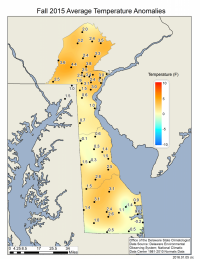
Data from the Delaware Environmental Observing System (DEOS) show that autumn temperatures across the entire State were above normal, except for a few stations in southern Sussex County and northern Kent County (Figure 3). Northern Delaware and Chester County, PA saw the largest positive temperature anomalies reaching greater than 3°F at several stations.

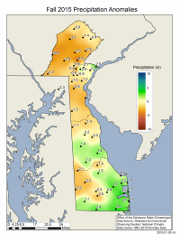
Autumn rainfall varied significantly across the State depending upon location. In general, the heaviest precipitation fell across coastal and southern Sussex County, while portions of northern Delaware and Chester County, PA saw the largest negative rainfall departures (Figure 4).

Autumn 2015 average temperature departures from the 1981-2010 mean based upon DEOS station data.

Figure 3. Autumn 2015 average temperature departures (°F) from the 1981-2010 mean based upon DEOS station data.
Autumn 2015 precipitation departures (inches) from the 1981-2010 mean based upon DEOS station data.

Figure 4. Autumn 2015 precipitation departures (inches) from the 1981-2010 mean based upon DEOS station data.
 
Syndicate content
Cars in Wilmington

Cool Temperatures and Near Normal Precipitation Characterize Delaware’s Climate During 2014

de_annualtemp_1895-2014_0.png

Figure 1. Delaware statewide annual mean temperature (°F) 1895-2014.
December monthly temperature anomalies.

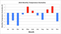
Figure 2. Delaware monthly temperature anomalies.

Annual Temperatures

Statewide mean annual temperature in 2014 was 54.8°F according to preliminary data from the National Climatic Data Center (NCDC). This was 0.6°F below the 1981-2010 normal of 55.4°F (Figure 1) and was the coolest year in Delaware since 2003.

Monthly temperatures varied greatly throughout the year (Figure 2). The first four months of 2014 saw much below normal temperatures accompanied by heavy snowfall across the State. Although late spring and early summer saw a return to above normal temperatures, the late summer climate was cooler than normal, a welcome respite from the summer heat for many residents. The year ended with a return to warmth in three of the last four months.

Annual Precipitation

Statewide precipitation in 2014 averaged 43.49 inches, 0.84 inches below the 1981-2010 mean of 44.33 inches (Figure 3).

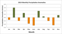
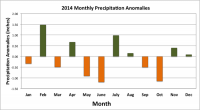
Monthly precipitation anomalies varied between positive and negative throughout the year, with six months of above normal and six months of below normal precipitation (Figure 4). None of the monthly precipitation anomalies were large, leading to the near normal annual total.

Statewide Spatial Averages

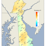
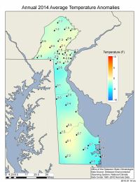
According to data from the Delaware Environmental Observing System (DEOS; deos.udel.edu), mean annual temperatures were below normal across the entire State with the largest negative anomalies found in coastal Sussex County (Figure 5).

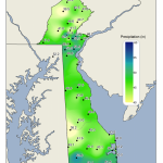
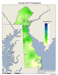
Precipitation across the region varied substantially in 2014, ranging from just under 39 inches to greater than 50 inches across the region (Figure 6).

de_annualprecip_1895-2014_0.png

Figure 3. Delaware statewide annual precipitation (inches) 1895-2014.
Delaware monthly precipitation anomalies.

Figure 4. Delaware monthly precipitation anomalies.
2014 mean annual temperature departures from the 1981-2010 mean based upon DEOS station data.

Figure 5. 2014 mean annual temperature departures from the 1981-2010 mean based upon DEOS station data.
2014 annual precipitation totals based upon DEOS station data.

Figure 6. 2014 annual precipitation totals based upon DEOS station data.
 
Syndicate content
Trees in Autumn

Warm and Dry Conditions Continue Across Delaware During October, 2014


October Temperatures

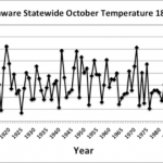
Preliminary data indicates that the statewide average temperature in October was 60.2°F, 3.1°F above the 1981-2010 normal of 57.1°F (Figure 1) and the 11th warmest October since 1895.

October Precipitation

Delaware’s preliminary statewide precipitation total for October 2014 averaged 2.38 inches, 1.08 inches below the 1981-2010 mean (Figure 2). This was the 2nd month in a row with below normal precipitation across the First State.

Statewide Spatial Averages

Data from the Delaware Environmental Observing System (DEOS) shows most stations experienced higher than normal temperatures during October, except for a few stations in southern New Castle and northern Kent counties (Figure 3).

Rainfall varied significantly across the region with generally lower totals in southern Delaware and the highest totals across Chester County, PA (Figure 4).

Images
Rainbow over Bridge

2013 Warm and Wet Across Delaware

Delaware’s 2013 climate was characterized by slightly warmer than normal temperatures and above normal precipitation values.


Annual Temperature

Statewide mean annual temperature in 2013 was 56.5°F according to preliminary data from the National Climatic Data Center (NCDC). This was 0.7°F above the 1981-2010 normal of 55.8°F (Figure 1) and was the fourth year in a row with above normal temperatures. However, this year was nearly 2.0°F cooler than 2012’s all time high value of 58.4°F.

Annual Precipitation

Statewide precipitation in 2013 averaged 49.93 inches, 4.07 inches above the 1981-2010 mean of 45.86 inches (Figure 2). Most areas of the state saw substantially above normal precipitation during the summer months, making the summer of 2013 the 5th wettest on record since 1895.

Statewide Spatial Averages

According to data from the Delaware Environmental Observing System (DEOS; deos.udel.edu), mean annual temperatures were above normal across portions of New Castle, western Kent and Sussex counties, and across Chester County, PA (Figure 3). Mean annual temperatures were below normal across the remainder of the State.

Precipitation was much above normal in all locations except southwestern Kent County and portions of Chester County, PA (Figure 4). The largest positive precipitation departures were found along the eastern portions of Sussex County where some locations received 10 inches more precipitation than normal.

Images
House in Autumn

October 2013 Brings Warm Temperatures and Near Normal Precipitation to Delaware

While precipitation and temperatures varied across the state, Delaware’s climate during October 2013 was generally characterized by warmer than normal temperatures and near normal precipitation values.

Delaware’s Climate during October 2013 was characterized by warmer than normal temperatures and near normal precipitation values.

de_statewideOctTemp-1895-2013_0.png

Figure 1. Delaware statewide mean October temperature (°F) 1895-2013.
de_statewideOctPrecip-1895-2013_0.png

Figure 2. Delaware statewide October precipitation (inches) 1895-2013.

October Temperatures

Preliminary data indicates that the statewide average temperature in October was 60.6°F. This was 3.1°F above the 1981-2010 normal of 57.5°F (Figure 1) and marks the first month since July with above normal temperatures.

October Precipitation

Delaware’s statewide precipitation for October 2013 averaged 3.87 inches, 0.25 inches above the 1981-2010 mean of 3.62 inches (Figure 2). Although only slightly above normal, this month’s precipitation was more than 3.0 inches greater than what fell in September.

Statewide Spatial Averages

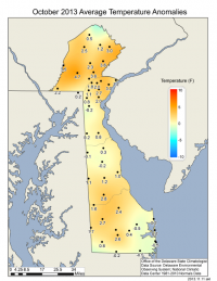
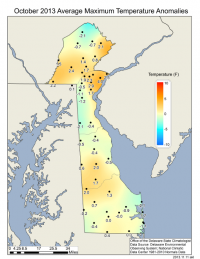
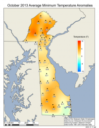
October average monthly temperatures were generally above normal across the DEOS (deos.udel.edu) network, except for stations along the Atlantic Coast and in extreme southern Sussex County (Figure 3). Average maximum temperatures varied across the state with below normal values found along the coast and in western New Castle and northern Kent Counties (Figure 4), while average minimum temperatures were more than 4°F above normal in several locations across the State (Figure 5).

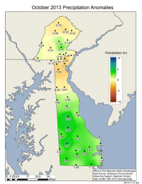
Precipitation was significantly below normal across most of New Castle County and Chester County, PA, while both Kent and Sussex Counties saw above normal precipitation for the month (Figure 6). Much of the precipitation in the southern portion of the state fell during the period from the 9th to 12th of October in association with a persistent coastal storm that brought heavy precipitation to this portion of the State.

October 2013 average temperature departures from the 1981-2010 mean based upon DEOS station data

Figure 3. October 2013 average temperature departures from the 1981-2010 mean based upon DEOS station data.
Delaware October 2013 maximum temperature departures from the 1981-2010 mean based upon DEOS station data

Figure 4. October 2013 maximum temperature departures from the 1981-2010 mean based upon DEOS station data
Delaware October 2013 minimum temperature departures from the 1981-2010 mean based upon DEOS station data

Figure 5. October 2013 minimum temperature departures from the 1981-2010 mean based upon DEOS station data
Delaware October 2013 precipitation departures from the 1981-2010 mean based upon DEOS station data

Figure 6. October 2013 precipitation departures from the 1981-2010 mean based upon DEOS station data
 
Syndicate content
Sunrise in Delaware

2012 is Warmest Year on Record for Delaware Since 1895

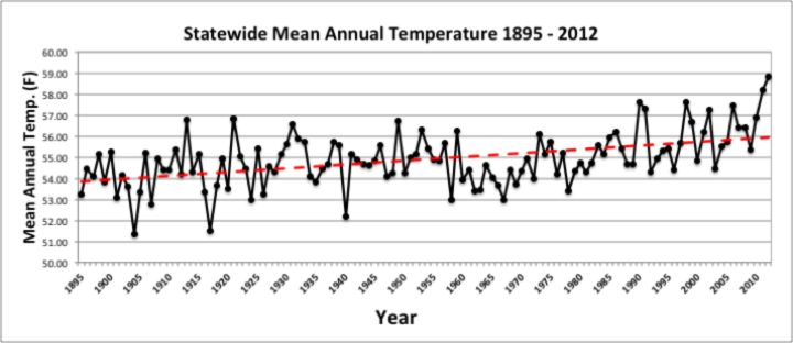
Statewide Mean Annual Temperature 1895-2012

Figure 1. Delaware statewide mean annual temperature (°F) 1895-2012.

Preliminary data indicates that Delaware saw its warmest year on record during 2012.

The mean annual temperature of 58.8 ° F was 3.9 ° F above the 1895 – 2012 mean temperature, making it the warmest year since records began in 1895.

This year broke the previous record of 58.1 ° F set in 2011.

The six warmest years on record have all occurred since 1990 (Figure 1).

The warm temperatures were accompanied by very dry conditions across the state during the year. The statewide mean precipitation of 34.53” was 10.05” below the 1895-2012 statewide mean, making 2012 the 6th driest year since records began in 1895 (Figure 2).

Conditions in Delaware mirrored those across much of the United States.

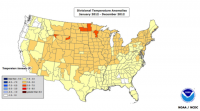
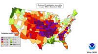
The contiguous 48 states had their highest temperature and 15th driest year since 1895 (Figures 3 and 4).

 
Statewide Annual Precipitation 1895-2012

Figure 2. Delaware statewide mean precipitation (inches) 1895-2012.
US temperature anomalies for 2012

Figure 3. Temperature anomalies (°F) across the contiguous United States. Map provided by the National Climatic Data Center.
US temperature anomalies for 2012

Figure 4. Precipitation anomalies (inches) across the contiguous United States. Map provided by the National Climatic Data Center.
 
Syndicate content
October Snow

October 2011 Snow Storm

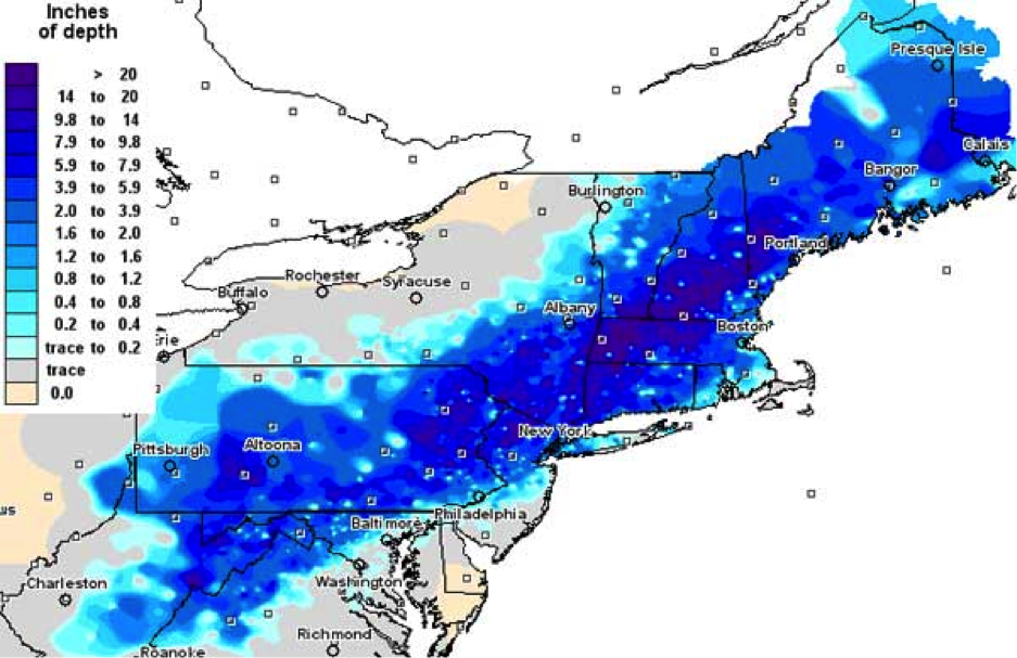
medium_2011oct-snow.pngAn unusual late October snowstorm blanketed the northeast United States with up to 20” of snow from the 28th through the 30th.

Snow fell across extreme northern Delaware throughout much of the day on October 29th, but melted quickly as it fell on warm surfaces.

In some areas of northern Delaware there was a slushy accumulation with an official accumulation of 0.3” measured in Wilmington.

On average, northern Delaware sees 18.9” of snowfall over the course of the season, with the first measurable snowfall usually occurring in November or December.

Monthly snowfall averages for Wilmington are given below.

Jan Feb Mar Apr Oct Nov Dec Season
7.5” 6.3” 2.2” 0.3” 0.1” 0.6” 1.9” 18.9”
 
Syndicate content